
Since it’s launch at INTERGEO 2017 in Berlin, the revolutionary new Leica GS18 T has been making headlines as the greatest innovation for surveyors for years. There was a palpable buzz of excitement in the demonstration area as people couldn’t believe the repeatability and functionality of the unit, many had a go themselves but couldn’t find fault with it’s reliability.
WATCH: Leica GS18 T Demo area at INTERGEO 2017
What Makes The Leica GS18 T Different?
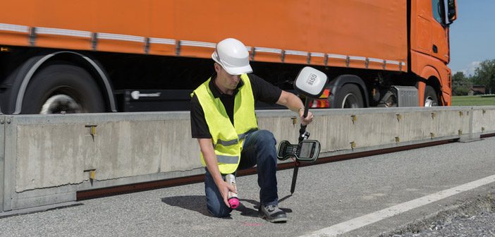
The new Leica GS18 T combines GNSS and Inertial Measurement Unit (IMU) to deliver the first true tilt compensation solution enabling surveyors to measure any point faster and easier without the need to hold the pole vertical and watch or level the bubble.
The Leica GS18 T is different from any other product in the market because it does not rely on a magnetometer to correct the pole tilt for each measurement. Magnetometers are affected by metallic objects, like vehicles, iron fences and even reinforced concrete, all of which are often found on construction sites.
Different to magnetometer-based GNSS antennas, the GS18 T’s tilt compensation does not need to be calibrated and is immune to metallic object interference thanks to the newly developed powerful and lightweight inertial micro unit (IMU), which is built into the GNSS antenna. The real -time tilt compensation combines GNSS data with the IMU’s tilt and direction values.
The Leica GS18 T is also a self-learning GNSS Smart Antenna with a high-class performance. This adaptive measurement engine with RTK plus provides measurement engineers on construction sites with the best position by automatically selecting the optimal signal combination.
A New Way Of Measuring
With a conventional GNSS RTK rover, points such as building corners, walls, fences, light posts or points underneath obstacles, like cars, cannot be directly measured with a vertical pole. To measure a building corner for example, you would have to measure a point nearby, and apply an offset to the point or measure it with an alternative method such as a total station – both options are time consuming.
With the Leica GS18 T, a building corner can be measured directly because the pole can be tilted and the pole tip placed easily and quickly to the corner. The same goes for all other difficult to reach objects, GS18 T literally makes measuring easier and quicker than ever before.
Where Can This Technology Take Us?
We certainly live in exciting times. The Leica GS18 T can be combined with Leica Captivate software to turn complex data into realistic and workable 3D models. The GS18 T also starts to introduce augmented reality into the survey field crews’ workflow as the unit measures the direction the antenna is heading and any data displayed in the 3D viewer on the controller is laid out in front of the user. This makes viewing the design in the field easier than ever before.
How is the Leica GS18 T different? For surveyors, this is next-level GNSS technology which has to be seen to be believed.
Experience the world’s fastest GNSS RTK Rover for yourself.
![]()