When Dunedin’s Baldwin Street lost the Guinness World Record title of “World’s Steepest Street” last year to Ffordd Pen Llech in Wales, Surveyor Toby Stoff immediately thought they must have measured it wrong.
“I just looked at it and thought there’s no way that’s steeper than Baldwin Street. Then I noticed they’d measured the Welsh street on the inside curve, completely against industry best practise. Basically it was a bit of a loop hole in the rules.” Toby Stoff, Surveyor – Clark Fortune McDonald
In true Kiwi style, he decided to survey both streets along the centreline himself to accurately compare their exact gradients.
Ten months later after amassing a raft of support in NZ, conducting media interviews and a crowd-funded trip to Wales, Toby successfully surveyed both streets and submitted his report to Guinness Book of World Records. They accepted Toby’s analysis and promptly overturned the ruling and reinstated Baldwin Street to its rightful title of “World’s Steepest Street”.
“This is a triumph for Toby, Dunedin and all Surveyors!” Ray Copeland, Managing Director – Global Survey
NZ Surveyors Rallied To The Cause
Surveyors across New Zealand rallied behind Toby’s campaign to reclaim the title for Dunedin, many knew the street well from their time studying at the University of Otago Survey School, including those in the Global Survey team.
Like others, we jumped at the chance to support Toby in this important search for the truth. Clearly there had not been a fair comparison of the streets as they were measured 22 years apart using different methodology.
In August 2019, we offered to scan Baldwin Street with a high spec Leica Laser Scanner and asked our counterpart in the UK to do the same for Toby’s subsequent visit to Wales.
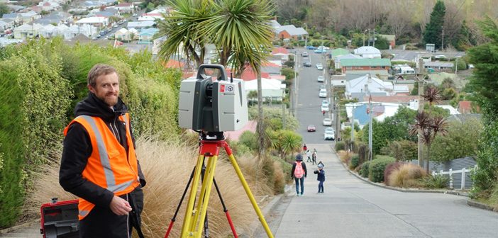
Photo: Lennon Bedford scanning Baldwin Street with the Leica P40 Laser Scanner
Surveyors universally agreed with Toby that the steepness of a street should always be determined by measuring on the centreline for the following reasons:
- It is standard practice in the surveying and engineering professions
- It provides a reasonable approximation of average gradient over the full width
- It allows straight and curved streets to be assessed equally
Credit to Guinness Book of World Records who have now amended the rules for this record to include measuring along the centreline.
A Deep Dive Into The Laser Scanning Data
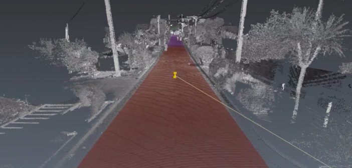
It may seem like using a sledgehammer to crack a walnut, but the advantage of laser scanning technology is its ability to digitally capture a complete environment very quickly and deliver a point cloud / 3D model. Software can then automatically analyse the laser scanning data in a multitude of ways to deliver highly accurate measurements.
From the point cloud data captured with the Leica Laser Scanners we produced a fly-through video of both streets which not only independently verify the maximum grades of the respective streets as measured by Toby, but also deliver a rich and complete visualisation of the grades of the road surfaces.
WATCH: Baldwin Street fly-through video:
One of our scanning specialists, Lennon Bedford overlaid the point clouds with textured models indicating the steepness of the street – the ‘hotter’ the colour, the steeper the grade.
The grade over the steepest 10m section of the road was calculated using a custom algorithm written in Leica Cyclone 3DR point cloud analysis software, developed in conjunction with Jennifer Ludwig from C. R. Kennedy in Australia. This algorithm effectively ran a 10m straight edge up the centreline of each street in 1cm increments and automatically identified the steepest section of road.
The maximum grade calculated by the algorithm for Baldwin Street was 34.9%, which is within 0.1% of Toby’s measured grade of 34.8%. As Baldwin Street is straight, the grade is the same across its width.
WATCH: Pfordd Pen Llech fly-through video:
The maximum grade calculated by the algorithm for Pfordd Pen Llech at the steepest part of the inner curve was exactly the same as Toby’s measured grade of 28.6%.
The colour gradient around the steep curve of Pfordd Pen Llech clearly illustrates the significant difference in gradient between the inside and the outside of the road.
Interestingly, the Leica Cyclone 3DR algorithm found a slightly steeper part of the centreline, just a few meters further around the curve, calculated at 29.3%.
This level of interrogation of the road surface was possible thanks to the extreme level of detail captured by the Leica Laser Scanners and provides a digital record for any future analysis of the data that may be required.
Baldwin Street in Dunedin rightfully has its title back and that is due to Toby Stoff’s persist determination and the great support he received from the Surveying community.
Read Toby’s full report as published in Survey & Spatial magazine
Connect with Lennon Bedford on LinkedIn to find out more about Leica Laser Scanning
Related Article: Accurately Measuring Baldwin Street’s Steepness
SHARE THIS ARTICLE