

Monitoring is often thought of as a discipline requiring the expertise of a specialist who possesses the unique knowledge needed to carry out monitoring tasks. In reality, monitoring is repeatedly and consistently surveying the same object and comparing the results over a period of time. On large and complex installations some additional knowledge of communications, power management and survey monitoring process is valuable, but in many cases Surveyors are well equipped to take on this work
This article explains some of the steps required to expand your traditional surveying services with monitoring.
STEP 1: Starting small with manual monitoring
What is monitoring?
Monitoring is simply nothing more than repeatedly surveying the same object and comparing the results over a period of time. The most common way Surveyors get started with monitoring is when a periodic check of an object are needed, such as yearly dam levelling, bi-monthly surveying of a seawall or weekly surveying of a bridge during its reconstruction.
Tasks like these are the first step from surveying to monitoring. Utilising a Leica level (e.g. LS10/LS15) and a Robotic Total Station like the Leica Viva TS16, functions can be executed by using Leica Captivate apps, Leica Infinity and potentially Excel to calculate displacements (the changes in position between measurements). This first step of the campaign (periodic) monitoring is called manual monitoring.
STEP 2: Expand into semi-automated campaign monitoring
When a large number of points need to be measured in shorter intervals (e.g. once a day), it becomes very time consuming to apply a manual monitoring approach; measure a large volume of points onsite, drive to the office, process the data, create a report and distribute by email. Not only is this inefficient, but also prone to errors and it is every Surveyor’s nightmare to reach the office and realise that one point measurement was accidentally missed!
Wouldn’t it be great to see the measurement results already in the field?
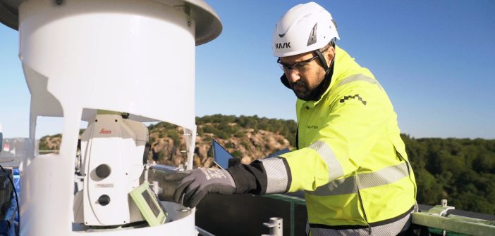
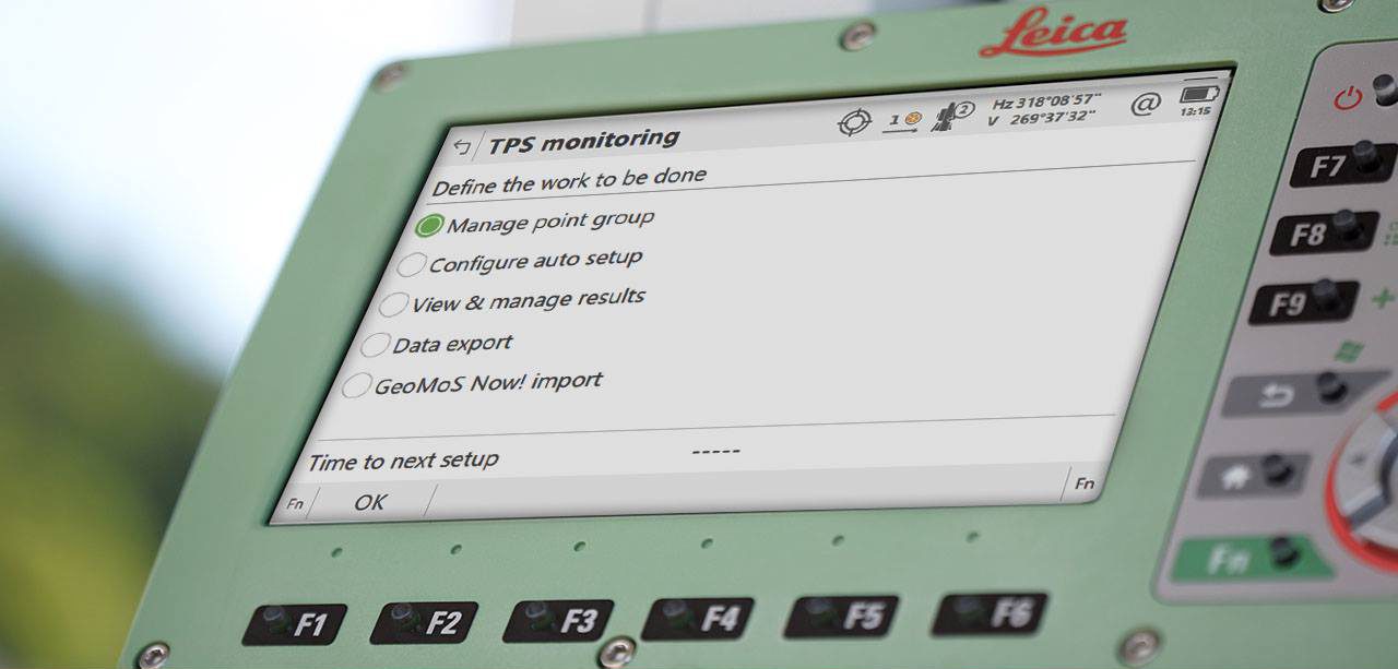
Take the next step into campaign monitoring and benefit from semi-automated data acquisition. Use the onboard Captivate TPS Monitoring app that is preloaded on every Leica TS16 instrument and ready for trial use. If it’s missing on your instrument, you can easily download it from myWorld, Leica Geosystems’ customer portal.
Why use the Leica Captivate TPS Monitoring app?
The TPS Monitoring app was developed to automate repeated measurements, it is also the first move towards automating the monitoring process. The Surveyor first needs to “teach” the instrument which points to measure by doing normal surveying measurements. After that, the app will automatically measure the points with the push of a button and even perform quality checks as it does the measurements.
The Surveyor sets how many rounds of measurements are needed and defines the reference (control) points and the monitoring points. At the end of the process, all the points in the instrument’s line of sight are measured with the highest accuracy using Automatic Target Recognition (ATR). The latest developments enhance the autonomous workflow, as the app can now compare the calculated deformation to defined tolerances and automatically notify stakeholders over email if and when movements exceed the thresholds.
Talk to our team about trialing the TPS Monitoring app with a demo license.
STEP 3: Optimising the workflow
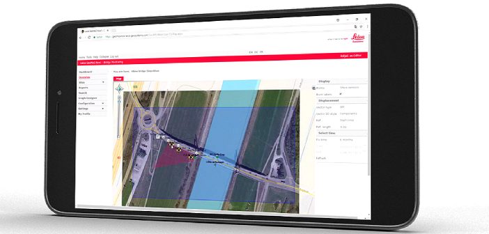
The Leica TPS Monitoring app significantly optimises the data acquisition workflow by increasing measurement quality and efficiency while reducing errors and operational resources. But there is still a lot of work to be done before sending the final report to a client or a stakeholder. This is where Leica GeoMoS Now! Survey Edition comes into play, a cloud-based service for the visualisation and analysis of monitoring data.
How to sync the measured data from the app to the cloud?
To begin with, the only thing that’s required is a smartphone. Each Leica GeoMoS Now! user gets log in credentials that need to be entered into the Leica TPS Monitoring app. A hotspot function on the smartphone can be used to share the internet connection with the total station. Nothing more is needed for the measurements to reach the cloud.
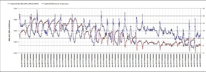
By using the smartphone browser and the login credentials from the TPS Monitoring app, the measured data can be imported into the project. As soon as this is done, the graphs with calculated displacements are automatically created on the dashboard. The whole process is automatic and the user can define the frequency of data sync.
In case of a missing internet connection, the data transfer can also be done via the SD card, the same as with any coordinate import or data transfer of levelling, total station and GNSS data.
Instantly accessing measurement results while standing next to the instrument in the field is a huge step forward in the workflow. However, there is still one task that needs to be completed before your monitoring work is finalised: creating a report and sending it to the responsible person. This is also easily done within Leica GeoMoS Now! SE. You can create a fully customized report template, and automatically generated reports will be emailed to recipients according to a user-defined schedule.
In this workflow, from the moment you push a button on the instrument till the moment you receive a monitoring report, the whole process runs automatically. This is why such a method is called semi-automated campaign monitoring.
What are the benefits of this workflow for a surveying company?
Semi-automated campaign monitoring is a great time – and cost-saver. There is no need to drive back to the office and lose time on something that can already be done in the field. The time saved with the new workflow can be used for several other site visits and measurement campaigns. As the number of campaign monitoring projects grows, you will start seeing a bigger return on investment, resulting in more profit.
What comes after campaign monitoring?
Let’s summarise the steps we took so far.
- We started with manual monitoring, where the normal surveying workflow with some help from Excel is needed to complete campaign monitoring tasks.
- The second step introduced optimisations to the data acquisition process for campaign monitoring by using the TPS monitoring app.
- The third step optimised the workflow by automating the processing, visualisation, and reporting tasks and eliminated the need for office work with Leica GeoMoS Now!
What is the future of monitoring?
Campaign monitoring may be a step out of the comfort zone for some Surveyors, but it is not a difficult step, nor a step into the unknown. Permanent and semi-permanent monitoring options are also available with GeoMos Now!
Adding monitoring to your company’s service offering has the potential of making it even more interesting, successful and ultimately more profitable.
To discuss your monitoring project with our expert team, contact us on info@globalsurvey.co.nz or 0800 453 422
SHARE THIS ARTICLE