

New Zealand Surveyors should be aware and prepared for the upcoming change in Survey regulations that will require Field Notes to be submitted with a Cadastral dataset.
Global Survey have developed stylesheets (in discussion with LINZ) to support this upcoming change in regulations. Survey jobs can either be exported directly from Leica Captivate or Viva instruments and controllers, or via a simulator through the new stylesheet to create a field note that can be submitted as part of the cadastral dataset.
Both TS and GS observations are supported in a single html report. This report /field note would be run as an additional export to the traditional workflow your office currently runs.
Stylesheets have been developed to support the following:
- Sorting the observational report on the fly – this enables the user to sort the observations by point name, code, time, quality etc. In the GNSS part of the report this feature brings massive benefit to the QA process. As it easily enables a check to make sure multiple GNSS epochs were observed over a split time during the survey.
- Photos, sketches, screen captures, and notes that are tagged to points will be displayed in the fieldnote report. This means that the field surveyor should only need the one device in the field to capture all the relevant information and occupation.
- The report fully supports the use of included angles (zero check) and will do the included angle check calculation on export of the report.
- The stylesheet can be set to support only the export of Cadastral codes – therefore your fieldbook does not get cluttered with all the occupational and topographical measurements that you may take during your survey.
- There are fields in the report that are editable (NOT observations) – this enables additional information to be added to the report or miscoded or named points to be changes or modified.
Once the Cadastral dataset is ready to be submitted the html report should be finalized and printed to a format that is acceptable for lodgment.
Working with 12d and Cadastral Field Notes
The following is a process you could look to use to get your 12d data into the field to maintain the XML attributes:
1. We would recommend that you give the data the approximate elevation of the site, so that any height scales factors can be applied to the fieldnotes (in 12d use Utilities/H-Z/Height)
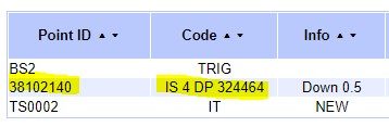
2. Export the data using Survey/Leica/1200/Strings as per the image below. If you export models with XML data, imported from Landonline, the Leica Point ID = oID of the Point, and the Leica Code = name of the point. If you export your traverse spreadsheets the Leica Point ID = Traverse point number, and the Leica Code = name of the point.

3. On board the instrument the xml file created in the panel above needs to be imported into the job.
4. The instrument map displayed is best configured to show point codes – this will display the names of the point as per below.
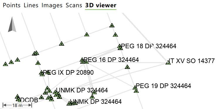
5. Points for Setups and Stakeouts (for old marks and placing new) are best selected from the Map display.
6. Upon completion of the job and exporting via one of the Cadastral fieldnote stylesheets the Leica Point id & Leica Code will easily help identify what has been collected in the field.
These Cadastral Field Notes stylesheets have been developed and are now available to our customers, including guidance on operation and reporting. If there is a requirement for further customisation of stylesheets, we can also assist with this.
Contact Bruce Robinson (bruce@globalsurvey.co.nz) to discuss your requirements for Cadastral Field Notes and Stylesheets
SHARE THIS ARTICLE