Have you ever been onsite, looking at the ground and thought “This would be so much easier if I could open up that trench again and take another look”. Ever been in the position where you’re looking at 2d plans and trying to imagine what the roofline will be like in reality? Or maybe you just need to know in detail exactly how the building will sit on the site in relation to its surroundings.
Introducing vGIS, the next evolution in augmented reality visuals that enables the user to overlay reality with high-accuracy 3D visuals.
Designed for digitally-focused AEC companies, utility management and service providers, vGIS delivers survey-grade accurate 3D visuals in a variety of ways.
Our 5 favourite things about vGIS are:
- It’s a versatile and powerful solution that’s easy to use.
- It’s brand agnostic and can be used either with your own device or GNSS.
- It is exceptionally accurate. With positioning accuracy of up to 1 cm with GNSS, sub-10 cm without GNSS and directional accuracy of up to ±0.1°.
- It’s compatible with just about every mobile device and workflow. Including multiple data sources such as AutoDesk BIM360, Bentley iTwin, Esri, Revit, SketchUp, ArcGIS, WFS, Esri Maps and Google Maps.
- The applications are very broad. It can benefit most above and below the ground construction projects from vertical design, GIS, underground locating, roading design, earthworks and even as-builts.
How can vGIS be used in a real scenario?
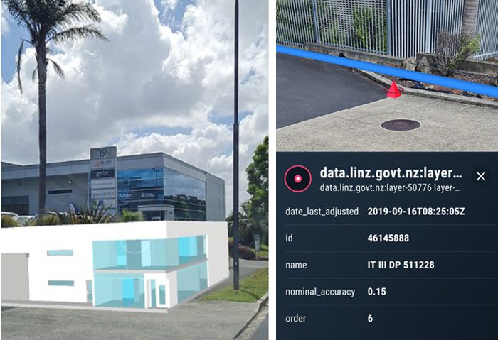
For the purposes of this example, we were hypothetically going to knock down our old office and build a new office on the same footprint. First we built the new 3D structure in Revit and attached a coordinate system, then we visited the site and used vGIS combined with the Leica Zeno FLX100 to view the AR visualisation of the new building in 3D in it’s exact position, as seen in the left-hand image above. [There is an intentional vertical offset to check alignment]
The right-hand image shows connection to the LINZ web feature service [WFS] where we can view LINZ data, which could include locating and identifying survey marks and boundaries.
How would vGIS improve the way you work?
Better Data Collaboration
You could ensure field workers from different companies, utilities, and subcontractors are all using the same data. For example on infrastructure projects, everyone involved on the project can literally see accurate visuals of the location of all underground structures, in real-time augmented reality. This helps preventing errors, whilst minimising delays and costly rework.
Experience Designs in 3D
All the Designers, Planners, Engineers and Architects on your project could experience an immersive 3D AR walkthrough of proposed buildings before construction begins. This enables more informed construction decisions and positively impacts design choices, helping the team identify issues or flaws that can be addressed early on in the process.
Early Clash Detection
Where are the hidden errors and design clashes in the design? With an AR view of prospective BIM designs, GIS data, and site information your team could interrogate the design from all angles in the context of the natural environment. This leads to early detection and prevention of design flaws.
Informative Customers Demos
Your clients will be impressed as you demonstrate the build project’s progress by allowing them to compare onsite construction to an augmented-reality view of the design, showing how the project is expected to look when finished.
Field-Office Collaboration
To coordinate project design and implementation, share augmented-reality visualisations of project designs and how they interact with the construction site. Instead of relying on manual measurements that are checked against physical blueprints, use 3D data to make comparisons and decisions.
Capture and Review Work in Progress
Comprehensively and accurately document work in progress by simply scanning the site with your phone’s camera or built-in LiDAR. Superimposing the scans on the physical world enables you to review the build and buried infrastructure with centimeter-level accuracy.
vGIS is a subscription based platform that is now available in New Zealand exclusively from Global Survey.
Talk to our expert team about a vGIS demo and 2 week free trial on your own device.
Call 0800 453 422 or email info@globalsurvey.co.nz
SHARE THIS ARTICLE