vGIS is a visualisation platform that transforms traditional BIM, GIS, Reality Capture and other types of spatial data into stunning augmented reality visuals. Now you can display proposed designs and existing infrastructure in the field and in real time, helping field workers locate assets faster, detect problems, and improve collaboration.
vGIS was designed to give users the best of both worlds: survey-grade accuracy and the ability to use the system on consumer devices without any additional hardware.
The system comes with multiple calibration methods that allow indoor and outdoor positioning and creates an instant view of how design impacts job site realities, helping you prevent errors that lead to project delays and expensive cost overruns.
vGIS is designed to aggregate data from multiple sources and formats. The system can display 3D models as accurate to-scale holograms and it can convert traditional 2D GIS data into BIM-quality 3D visuals. Supported formats include AutoDesk BIM360, Bentley iTwin, Esri, Revit, SketchUp, Esri Maps and Google Maps.
vGIS Key Features:
- Exceptional Accuracy – vGIS offers exceptional accuracy with and without external GNSS devices. Positioning accuracy of up to 1 cm with GNSS and sub-10 cm without GNSS. Directional accuracy of up to ±0.1°.
- Stable Visualisations – 3D Augmented Reality overlays stay “world-locked” by remaining in sync with the physical world.
- Multi-Device Support – vGIS can be used with iPhone, Android, Microsoft HoloLens, and Windows Mixed Reality.
- No Additional Equipment – vGIS runs with high-accuracy and high-fidelity on consumer devices without additional equipment.
- Multiple Positioning Methods – vGIS supports multiple positioning methods optimized to address different use cases.
- GIS Data Collection – Comprehensive GIS data collection and issue reporting capabilities.
- Advanced Collaboration – Integrated holograms, video, and audio that connect the office with field teams.
- GIS Integration – Bi-directional integration with Esri ArcGIS and other GIS systems.
- Multi-Format Support – Support of Esri ArcGIS, WMS/WFS, Shapefile, KML, Geo database and other formats.
- GNSS Integration – Compatible with high-precision GNSS devices of any brand.
- Multi-View Support – First-person on-site experience and birds-eye “zoom out” site overviews.
- IoT Integration – Capabilities of displaying real-time IoT and sensory data in Augmented Reality views.
- 3rd-Party API Support – Additional bi-directional integration options through native APIs.
vGIS and Leica Geosystems
High-accuracy augmented reality requires top-of-the-line hardware that works hand in glove with the AR software. In collaboration with Leica Geosystems, vGIS delivers survey-grade AR capabilities in portable, reliable, and affordable packages.
Combining vGIS’s extended reality visualisation platform with Leica’s centimeter-level positioning hardware enables you to experience augmented reality more sharply and vividly than ever.
There are several Survey GNSS hardware options that are compatible with vGIS platform:
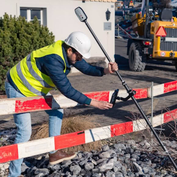
Leica Zeno FLX100
A perfect positioning solution for high-accuracy mobile augmented reality. Location data is a basis for decision-making in any industry. The Leica Zeno FLX100 smart antenna captures spatial data simply and flexibly, giving you the freedom to work the way you want to work.
A universal handheld tray or an array of lightweight mounting brackets enables you to pair the Leica Zeno FLX100 with your own smartphone or tablet. For more accurate data capture just connect to Smartfix RTK network and mount the FLX100 on a survey pole.
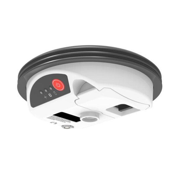
Leica GG04 plus
A high-end package for demanding environments. Leica GG04 plus gives you cutting-edge GNSS technology and industry-leading 555 channel tracking. The rugged, flexible, and easy-to-use smart antenna uses RTK technology and can apply Precise Point Positioning.
This makes high-accuracy augmented reality and data collection possible in real time even in the most demanding of locations without the need for a mobile data connection. With its compact, lightweight design and IP68 durability, you can work longer under any conditions.
Hardware Supported
vGIS is hardware-agnostic. It can run on any suitable device, including Android and iOS phones, tablets, and Microsoft HoloLens, which allows you to select the optimal tools for the job. vGIS supports over 300 devices across multiple operating systems.
Positioning Methods
- Survey-grade GNSS/RTK
- Pro consumer-grade GNSS/RTK
- High-accuracy GNSS-less calibration
- Manual placement
- Image and surface recognition
Positioning Accuracy
GNSS/RTK*
- Horizontal: 1 cm + 1 ppm RMS
- Vertical: 2 cm + 1 ppm RMS
- Directional: +/-0.1°
GNSS-less*
- Horizontal: sub-15 cm
- Vertical: N/A
- Directional: +/-0.1°
* Best-case scenario
Connectivity
- Cellular
- Wi-Fi
Infrastructure Projects
With vGIS, you can keep field workers from different companies, utilities, and subcontractors all on the same page. vGIS enables everyone involved in an infrastructure project to be fully aware of all underground structures, preventing errors, delays, and cost overruns.
Clash Detection
Help your teams to quickly understand design clashes and find hidden errors by providing them with an AR view of prospective BIM designs, GIS data, and site information. Your workers are more likely to find clashes, thereby preventing errors and cost overruns, when they can view designs from all angles in the context of the natural environment.
Design Reviews
Engineers, decision makers, and others can conduct more productive design reviews by transforming two-dimensional blueprint discussions into immersive 3D augmented-reality walkthroughs. When they see the impact of design choices, design teams make more informed design decisions and make them faster, and they catch potential design flaws before they occur.
Customer Onsite Demo
Easily demonstrate progress by allowing customers to compare on-site construction to an augmented-reality view of the design, showing how the project is expected to look when finished.
Field-Office Collaboration
To coordinate project design and implementation, share augmented-reality visualizations of project designs and how they interact with the construction site. Instead of relying on manual measurements that are checked against physical blueprints, use 3D data to make comparisons.
Capture and Review Work in Progress
Comprehensively and accurately document work in progress by simply scanning the site with your phone’s camera or built-in LiDAR. Superimposing the scans on the physical world enables you to review buried infrastructure with centimeter-level accuracy.