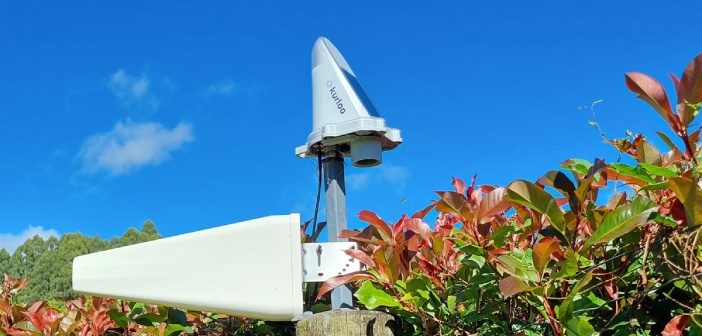
The Kurloo monitoring solution for displacement and slope monitoring is a two-part system. The first part is the Kurloo device, which is mounted on the site you want to monitor. This device gathers precise data remotely using its on-board GNSS components and environmental sensors. Even small movements can be detected by the Kurloo device, making it ideal for slope monitoring applications. The environmental sensors can also provide valuable data about slope instability.
Before introducing Kurloo to the New Zealand market, our technical team conducted rigorous testing to ensure its effectiveness in New Zealand’s specific conditions.
We set up three separate trial monitoring sites over several months with the objective of testing the following performance metrics:
- Expected precision of the Kurloo sensor
- Reliability of solar as an energy source
- Alerting, data extraction, and interpretation

Expected precision of the Kurloo sensor
Test #1: Expected precision of the Kurloo sensor
The accuracy of post-processed GNSS (Global Navigation Satellite System) data depends on two main factors:
Amount of data collected: Generally, more data leads to higher precision.
Distance between the reference and rover points: Shorter distances typically result in better accuracy.
Our Test Results:
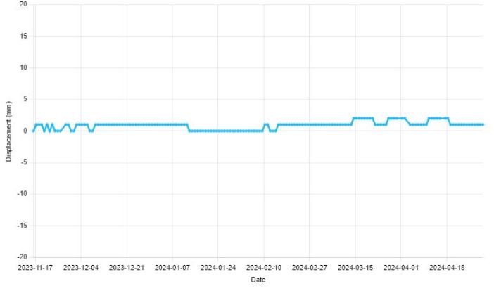
In our six-month test with a 10-meter baseline (distance between reference and rover points), we observed the following:
Maximum deviation of 5mm in the moving average of height data (the specified solution allows for 3mm + 1.0 ppm RMS).
Moving average of position deviation was only 2mm. These results demonstrate that longer measurement periods can lead to improved precision.
There is always a trade-off between range and data collection time in GNSS monitoring projects. More power will be drawn from the solar battery if more data is collected to increase precision. This needs to be considered during project planning.
Conclusion: The Kurloo device’s precision is consistently within the specifications.

Reliability of solar as an energy source
Test #2: Reliability of solar as an energy source
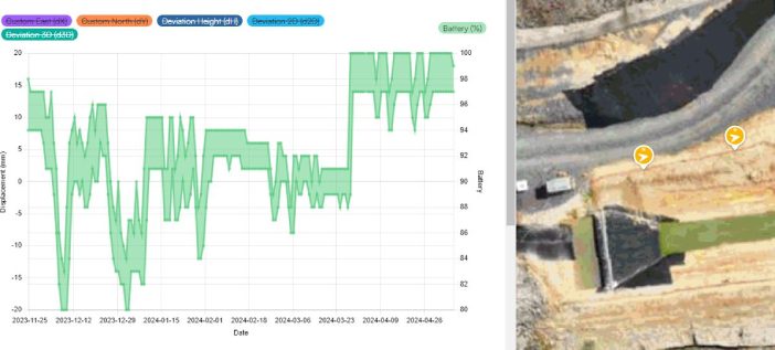
Kurloo units leverage solar power to ensure reliable and autonomous operation in even the most remote locations. This innovative design allows the unit to automatically power on, log GNSS data, and seamlessly transmit it to the cloud via a secure communications link. Furthermore, the battery level, along with all collected data, can be conveniently monitored remotely through the Kurloo Nest cloud-based portal.
Our rigorous testing in Auckland, known for its variable weather conditions, further underscores the effectiveness of this solar-powered design. Impressively, the battery level consistently remained above 80% throughout a 6-month trial period. This exceptional performance highlights the unit’s ability to maintain uninterrupted operation even in environments with less-than-ideal sunlight, making it a truly dependable solution for remote monitoring applications.
Moreover, the integrated 1.5W solar panel and robust 46AH rechargeable battery power these operations, enabling the unit to function for up to 21 days without any direct sunlight. This remarkable self-sufficiency eliminates the need for frequent battery replacements or external power sources, significantly reducing maintenance costs and ensuring continuous data collection.
Conclusion: The solar battery is very reliable, even in less than optimal conditions.

Data extraction and interpretation
Test #3: Alerting, data extraction and interpretation
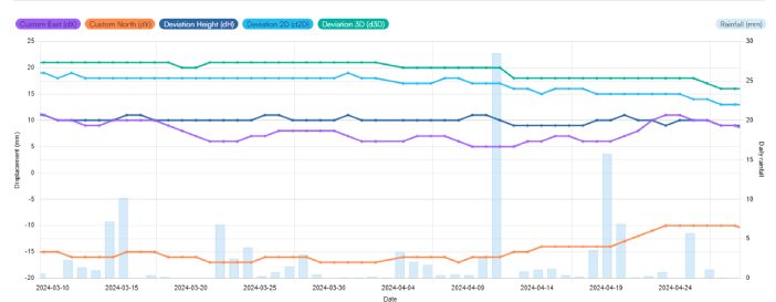
The Kurloo Nest cloud-based portal simplifies the monitoring process by allowing users to create various alerts based on sensor displacement or status, such as battery level or other relevant metrics. These alerts can be triggered by single data points or moving averages, with customisable thresholds for enhanced flexibility.
Kurloo automatically integrates with the NZ Metservice and rainfall associated with the nearest gauge to the monitoring project is automatically brought into the Nest to help in the interpretation of movement with environmental conditions.
The Kurloo Nest dashboard provides users with the flexibility to receive alerts either as notifications within the dashboard itself or as email alerts, ensuring they are promptly informed of any notable changes in their monitored data. Additionally, all measured point and sensor data are securely stored within the Kurloo Nest platform and can be easily exported as a .CSV file, allowing for convenient backups and further analysis using other software tools.
Conclusion: Kurloo Next is easy to use and has useful alert features and dynamic data reporting options.
| “Our New Zealand field testing of the Kurloo solution left us highly impressed. The Kurloo solution is brilliantly simple and yet delivers powerful data insights for monitoring projects,eliminating the need for frequent site visits thanks to its low-maintenance design.
The daily rate pricing model is another perk, making Kurloo a cost-effective option for monitoring projects in New Zealand – significantly more affordable than other solutions on the market. In short, Kurloo offers an accessible, affordable monitoring solution that delivers valuable insights” – Bruce Robinson, Director at Global Survey |
 |
Invented and made in Australia by geospatial experts, Kurloo monitoring technology are exclusively available in New Zealand from Global Survey.
For more information contact our monitoring specialists on 0800 453 422 or info@globalsurvey.co.nz
SHARE THIS ARTICLE


