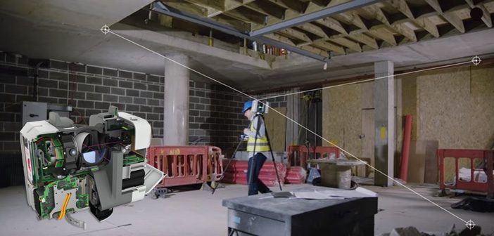
With the Leica RTC360 laser scanner, you’ll find that delivering precise data is easier and quicker than ever before. With lightning fast point cloud and HDR image capture at 2 million points per second, the RTC360 offers unparalleled scanning productivity.
Let the innovative VIS Technology guide you from one setup to the next by using the new scanner Live Position feature in the newly released Leica Cyclone FIELD 360 software.
While scanning with the Leica RTC360, users can operate their laser scanner and perform on-site point cloud pre-registration, straight from an iOS or Android device. With its intuitive user interface, and immediate data visualisation, the Cyclone FIELD 360 app allows users to quality control their scans directly in the field.
In complex environments it is often difficult to identify scan shadows and find the ideal place for an additional setup to be taken. Also, in repetitive structures it can be easy to lose track of what already has been scanned. With automatic pre-registration in the field, thanks to Visual Inertial System (VIS) Technology, the RTC360 reduces the complexity and the time of your office work. High-quality point clouds are quickly available for your downstream deliverables.
How VIS Technology Works
VIS Technology was developed to decrease the time spent on stitching together the individual point clouds into one complete point cloud. The system is based on five cameras built in to the RTC360 to track the environment. These cameras pick up on environmental features and use them as reference points to connect individual scans.
When moving from one place to another, even between floors, the RTC360 knows the relative position between any two scans and automatically pre-registers the different point clouds into one complete point cloud.
With the latest release of the Cyclone FIELD 360 app, the innovative VIS Technology is displayed instantly and live on the tablet. The current scanner position is always plotted in the Map view of the app and can be used to guide the user towards the ideal next setup location.
This enables users to:
- Switch on Live Position to view current scanner position
- Find the ideal position for the next scan
- Avoid holes in the overall scene
- Avoid unscanned areas
Once all scans are checked and registered through Cyclone FIELD 360, the data is synchronised back to the RTC360 scanner, which records the data on an USB stick for post-processing in the office.
Read Customer Story: Envivo impressed with Leica RTC360 laser scanner
Contact Tim Jervis to discuss the Leica RTC360 solution or email info@globalsurvey.co.nz
SHARE THIS ARTICLE