The GNSS Evolution
This is the story of a decade-long quest for sensor integration, the results of which provide a glimpse into the future of not only GNSS rovers, but also perhaps other surveying and mapping instruments to come.
The key differences between Leica Geosystems’ GS18 T tilt compensation and that of many other systems released recently is that it is does not rely on a magnetic compass, and it does not require the user to go through a calibration process.
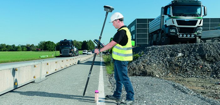
It self-calibrates through an integration of the GNSS engine working in concert with MEMs based inertial measurement units (IMUs). You can start observing points as soon as you move to the first point, and you do not have to worry about leveling up the pole—at all.
Not to be overlooked, the system has been designed specifically to mitigate the effects of working with satellites at low angles when the rover head is tilted.
Beyond The Electronic Bubble
Electronic bubbles and tilt compensation are not completely new developments, with compensaters standard in many instruments, such as total stations, and with multi-sensor GNSS and IMUs having been in mobile systems for road, sea and air for many years. Tilt is not new to GNSS rovers either, though this particular implementation is in many ways completely new.
When Leica Geosystems stated their new GNSS rover was “magnetically immune, self-calibrating tilt capabilities” many wondered if they were just playing catch up. It turns out that was not the case.
“The main thing we wanted to do for the user was to make measurements fast. We wanted to make it easier, to solve the common problems with tilt compensation, and reduce the typical errors. We have now released the GS18 T. The ‘T’ means tilt, as the first truly magnetically immune GNSS rover and calibration free.” – Bernhard Richter, GNSS business director at Leica Geosystems
According to Richter, they followed four rules while developing this new revolutionary solution:
- We cannot control the magnetic field of the Earth. It varies a lot, and there are many magnetic hazards. Trucks and excavators have a big magnetic influence. We would not develop a magnetic-based system.
- [We want to] enable the user to measure as fast as possible without having to watch the bubble, no matter how much it is tilted from the vertical—even 30 to 40 degrees to get the antenna away from objects.
- [The user must] be able to take it out of the box and begin working immediately. With compass-based systems you need to calibrate. When tilted, we project the antenna phase center on the ground, this intersection as a circle. But to place the position on the circle we want this relative to true north—WGS84—and we will use GNSS and velocity to determine this angle.
- [We want to] develop a rapid ‘self-calibration’ that requires no additional user action. Once you start moving, as a normal part of your field work, you provide acceleration and GNSS orientation. This is the only calibration, and it is only needed to initialize direction. If you hold still it will eventually lose that calibration, but only a small amount of movement is required to re-calibrate rapidly. The calibration is constantly updated as you keep moving.”
Mobile mapping, airborne mapping, and marine navigation systems benefit from the integration of multiple sensors: GNSS, accelerometers, gyros, airspeed, and velocity sensors.
The challenge in doing this on a GNSS rover is size. These [marine, airborne, mobile] systems are large. We cannot put in a large $20K gyroscope as accurate as one on an Airbus 320 on a rover. So we consulted with our partner NovAtel for some early things, but then we developed and produced all of our tilt sensors at Leica Geosystems.”
How Precise?
No matter how good the tilt computation, there will be some additional error, but not as much as you’d think. Richter said, “In the past, to measure a true north azimuth, people used cumbersome surveying methods: astronomic, or high-end gyros, separated GNSS observations, or total stations and GNSS together. Now with this tech, out of short movement, we get a true north azimuth better than a two degrees.”
“If you just measure topo points for a few epochs, there is no need any more to stay there,” Richter said. “This only averages the manual movement. The [GS18 T] is now faster and more accurate, and you can go down to 30 or more degrees with no drift.”
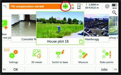
But how do you know it’s working? Richter responded, “There is a green bubble on our precision symbol in the [Captivate] software and also a lighted symbol on the antenna. You see a tilted pole that turns from red to green. You can follow what is happening around you—you are not stuck looking at a bubble.”
The Development
Leica Geosystems and parent company Hexagon are adamant about emphasizing teamwork. Richter said, “We have a very bright team, and it is unfair to name just a few,” but that certain team members stood out at pivotal points in the design process.
“The motivation was to improve workflow, and the idea started about ten years ago – the first patents were filed then,” said Richter. “A very bright young guy in our Brisbane office, Dr Damien Dusha, was involved in some of those patents. He also built devices to test the tilt, to prove that it would work. He built some crazy designs, with multiple antennas, prisms, and four total stations to test the precision. Damien proved it would work.”
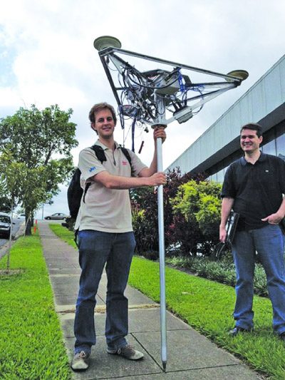
Above: Dr. Damien Dusha of Leica Geosystems Brisbane facility [right] with an early prototype constructed to prove that a hybridization of GNSS and multiple motion sensors could self calibrate and maintain precise tilt compensation.
Proving an idea can work is one matter but “making it work 24/7” as Richter put it, is another.
“Another very bright guy, Dr. Matteo Carrera [GNSS algorithm engineer at Leica Geosystems, Switzerland] made that idea work.”
Like others on Leica Geosystems design teams, Carrera and Dusha have distinguished scientific backgrounds. Before joining the company, Carrera researched subjects the likes of gravitational physics and the relativistic effects on orbits and tracking of space vehicles.
Dusha, a software engineer for Leica Geosystems in Queensland, Australia, has a background in avionics and signal processing, and his doctoral thesis was on a fusion of GNSS and computer vision for navigation. Rest assured that very bright people are designing that gear you purchase.
Read “What Makes The Leica GS18 T Different”
This article is an exert from xyHt Magazine, Read The Full Article.
SHARE THIS ARTICLE