When people say ‘Reality Capture’ they often mean devices that produce point clouds. But, at a fundamental level, Reality Capture is capturing the real world and creating a 3D digital representation of it. Isn’t this what Surveyors have been doing since day one?
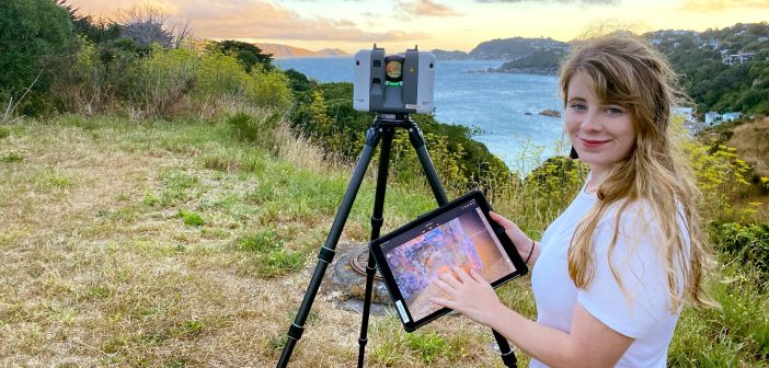
Newer reality capture methods, like terrestrial laser scanning (TLS) and photogrammetry, have developed from the principles of traditional surveying (see illustration below). In a relatively short amount of time, we have gone from selectively capturing 1 GNSS shot per minute, to non-selectively getting 2 million points per a second with the Leica RTC360 laser scanner.
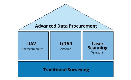
Image credit: https://www.geoweeknews.com/news/realitycapture101
The efficiency gains that newer methods offer over traditional methods (GPS and total stations), particularly for large or remote sites, are immense. Newer methods enable more data to be collected, faster delivery and great visualisation power in end outputs. As a result, UAV photogrammetry and TLS are globally fast becoming embedded in the Surveyor’s toolkit.
The traditional methods of reality capture obviously do still very much have their place, but it’s all use case specific. The computer requirements and big data management involved with newer methods is immense, and not always necessary for what you’re trying to achieve. Whilst GNSS and total station instruments are still the domain of the Surveyor, laser scanners and photogrammetry have a much wider array of use cases across a business and through-out different industries.
Myths about all point clouds ‘being the same’ and laser scanning just being ‘point and shoot’ are being perpetuated. A key point of difference for Surveyors is the ability to get mm precision from these point cloud outputs.
The Power of Visualisation
Reality capture is not a point solution, the use cases are manifold and diverse. But often newer methods are adopted in a business as a point solution. Deliverables are regularly focused on the ‘mm precision’ element of the outputs. However, this emphasis can detract from the 3D visuals that are delivered. Visualisations are a powerful tool for stakeholder engagement in their own right.
Frequently the end outputs are 2D drawings with their own symbology and layering language, seeing a visual of asbuilt conditions can be a much more effective communication tool.
Your client, who may not be experienced at looking at these plans, can struggle to understand the design intent and physicality of the structure as seen in a 2D format. With the 3D visualizations that newer reality capture methods produce, all stakeholders can now see and interact with the design. This enabling them to intuitively understand asbuilt, conditions as a basis for discussion about proposed changes. These visualisations are also very powerful for condition assessment and continual management of remote assets.
How Do You Compete?
The development of this technology is changing how we work and what we deliver, and with pushes towards autonomy, e.g. the development of autonomous mobile mapping capture solutions or automated extraction workflows, this is a continuously evolving process. So it is important that you have a digital strategy for the adoption of this technology across your business.
On top of this, new reality capture software and hardware is released every day. It is like we are on a long train ride with an unknown destination. With emerging technology arriving at pace, we are said to be in the grips of a fourth industrial revolution. The industry 4.0 as McKinsey & Company are calling it. As a result, our BAU processes are changing – but are we changing? ‘Surveyors as the data managers’ has become an industry catchphrase. Are you observing this catchphrase or is your company actively adapting?
What’s Your Digital Strategy?
A key part of my role at Global Survey is to be the expert and stay up to date with emerging technology in this space. This is a challenge because of the volumes of new hardware and software coming out every day. My time is mostly spent providing technical training and support for our customers on their reality capture digital journey, refining workflows, consulting on best practice. My job enables me time to do this research, but in a consult role you likely won’t have this research time. How is your team staying up to date?
Cross department collaboration is often the key element. As soon as a point cloud leaves your company, it’s really hard to retain disclaimers on its quality. Any “bad” data that has gone out there has come from your company, not a specific department, so it’s important that there are is collaboration and quality assurance processes in place.
A successful digital strategy for the deployment of reality capture methods is also is key to recruitment and retention which, currently, in the surveying industry is critical.
One of the things I’ve observed, is that it’s the companies that have good internal cross company collaboration that are most successful. Discussing different use cases across different departments is key. Having lessons learn on large TLS scanning jobs is critical!
Planning how you adapt to technology is imperative. As Benjamin Franklin put it ““By failing to plan, you are preparing to fail”.
What is your digital strategy for the adoption of reality capture technology?
This article first appeared in Survey and Spatial Magazine Author: Kirsty Mackie – Reality Capture and Autonomous Survey BDM, Global Survey.
Contact Kirsty for specialist Reality Capture and Digital Strategy insights.
kirsty@globalsurvey.co.nz | LinkedIn
SHARE THIS ARTICLE