
The landscape of Auckland has been primarily shaped by historic volcanic activity. A sprawling city located in an isthmus, home to a network of over 50 dormant and extinct volcanoes. Numerous above ground volcanic cones are prominent features of the city’s skyline, but what many residents don’t realise is that beneath the ground hides a vast network of underground lava caves.
A by-product of Auckland’s active volcanic history, the lava caves range from huge caves running a few hundred meters deep, to tiny little flows. Some lava caves lie perilously close to the surface and can be found in some of Auckland’s most prestigious suburbs. Despite the volcano field being inactive, these shallow lava caves continue to present structural problems for owners of the buildings located above them. There is very little information on the extent of the cave network as no large-scale lava cave mapping has ever been completed.
Lava Cave Mapping
As a reality capture solutions provider, Global Survey recently assisted on a lava cave mapping project. The objective was to determine the depth of ground between the underside of the property and the roof of the cave. Two of our reality capture experts, Tim Jervis and Lennon Bedford, teamed up to find a solution for this scanning project.
The cave entrance was very narrow, opening out to a space not even high enough to stand up in, so getting equipment into the cave would prove challenging. The team decided that the Leica BLK360 laser scanner was the perfect tool to take underground because it’s compact size and light weight would enable it to be used inside the confines of the lava cave.
In total, the Leica BLK360 was used to complete 18 scans in less than 2 hours, they captured the exterior of the villa and inside of the cave. As the cave was unlit and irregular in shape, targets were used to ensure that a tight registration could be achieved. The scans were then registered together in Cyclone Register 360 before being imported into 3D Reshaper to carry out some analysis.
“The beauty of the BLK360 for this project is that it’s fast, light and easy to move around the site. We were able to capture the full data set in very little time, which meant less time spent underground” – Tim Jervis
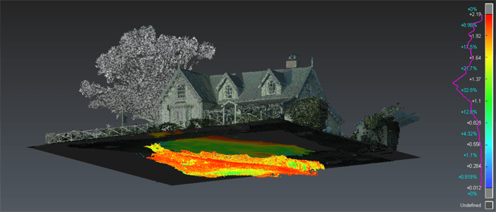
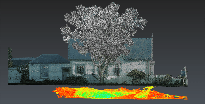
The depth of ground between the house and lava cave was found to be approximately 0.5 meters at its shallowest to just over 2 meters at its deepest.
Data Analysis Workflow

The data was captured using the Leica BLK360 and registered together using a combination of cloud to cloud and target registration techniques inside Cyclone Register 360. The data was then published to Leica’s new .lgs file format and opened in 3D Reshaper for analysis.
The first step of the analysis was the separation of the point cloud into two parts, one containing the below ground information, and the other the above ground information. The cave was then hidden from view and a plane was extracted representing the ground level of the villa – extracting this plane was crucial, as it provided a surface on which to base the comparison.
Next a surface to cloud comparison was completed along the z axis and the results were projected onto the surface of the plane. Colourising the outcome in a heatmap style produced a very clear representation of the depth of the cave beneath the villa.
The results can then be utilised downstream for calculating the structural stability of the ground, and whether any additional strengthening work needs to be undertaken.
Talk to us about Leica reality capture solutions – 0800 453 422 or info@globalsurvey.co.nz
SHARE THIS ARTICLE