CB Civil trials digital geo-fencing technology to enhance safety and productivity on KiwiRail’s national upgrade programme.
KiwiRail’s Rail Network Rebuild (RNR) programme is focused on clearing maintenance backlogs, lifting infrastructure standards across the Auckland Metro area, and preparing the network for the operational demands of the City Rail Link (CRL).
Upgrades are currently delivered under planned Blocks of Line, carefully scheduled shutdowns that provide contractors with full corridor access while maintaining public and worker safety. Each access window is tightly managed to maximise productivity within limited timeframes.
Once CRL services commence, full shutdowns will be harder to schedule. Maintenance and renewals will instead occur under single line running, where trains operate on one main while work proceeds safely on the adjacent line. Contractors must follow the “bucket down and bay lever disengaged” rule when trains pass nearby, essential for safety but restrictive for productivity.
To prepare for this shift, KiwiRail and its partners are trialing digital engineering controls, such as geofencing technology, that can maintain safety while enabling productive work alongside live operations.

Successful trails bring future change
In partnership with KiwiRail, Global Survey and Cable Price, CB Civil has completed two successful trials of digital geofencing collision-avoidance technology, assessing how machine-control systems can improve safety and efficiency in rail construction.
CB Civil has partnered with KiwiRail over several years to explore innovative technologies aimed at shifting from administrative to engineering controls. According to Fleet Asset Manager Tom Fisher, the latest trials offer a valuable opportunity to assess system performance in a simulated single-line rail environment.
The first trial, held at the northern side of Manurewa Train Station during the June–July 2025 Block of Line, proved the Leica + Xwatch integration concept for ballast removal and formation excavation in a confined corridor. The second, just south of the Te Mahia Train Station and still on the Papakura–Wiri corridor in September 2025 (School Holidays Term 3 Block of Line), built on those results with refined offset settings, enhanced data verification, and a simulated single-line-running setup using Vortok fencing.

Across both trials, the team safely completed full excavation, and formation works within the geofenced environment. The system operated effectively, showing strong potential for broader adoption following minor refinements to offset logic and operator smoothness.
How Does Collision Avoidance Work?
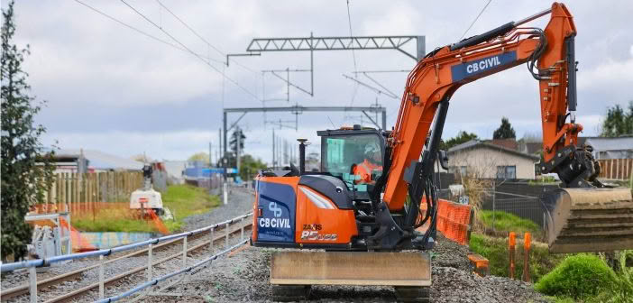
CB Civil fitted a Hitachi ZX85USB-7 (8.5 t) excavator with a Leica iCON MC1 3D Machine Control System integrated with an Xwatch XW5 safety controller.
The system enables multiple digital avoidance models to be loaded, applying KiwiRail’s minimum approach-distance (MAD) criteria to create precise geofence zones around overhead lines, poles, gantries, tunnels, or the adjacent track centreline.

During operation, the controller continuously compares the excavator’s moving components against those digital boundaries. As the machine approaches a limit, its hydraulics automatically slow proportionally; if it reaches the boundary, motion is cut completely, preventing any breach of KiwiRail’s exclusion zones.
This engineered safeguard enhances spatial awareness, reduces human-error risk, and protects both assets and personnel.
| “Safety and productivity are equally critical on civil and infrastructure projects — none more so than in rail, CB Civil and KiwiRail are trialing Leica’s globally recognised geofencing technology under New Zealand conditions as part of their single-line-running initiative. Our team provides technical advice, training, and calibration support to deliver greater safety and efficiency — without the need to close large sections of the network.” – Ray Copeland – Managing Director, Global Survey. “ |  |
Verifying Data with Augmented Reality Software
Before each trial, KiwiRail’s survey team used vGIS Augmented Reality software to verify all digital asset data. vGIS pairs a high-precision RTK GNSS receiver with a tablet or iPad to overlay digital models directly onto the physical environment. This allowed field crews to confirm that every mast, track centre, and service location was spatially correct before the data was uploaded into the machine-control unit — ensuring the avoidance zones accurately matched on-site conditions.

Trial Results and Performance
CB Civil reported that the geofencing collision-avoidance system operated safely and reliably, with some minor offset-related stoppages that did not materially affect productivity.
Key outcomes from the trial included:
- Productivity Maintained: Average excavation rates were consistent with traditional methods for similar-sized equipment and scope.
- Safety First: The system automatically slowed and stopped the excavator before breaching KiwiRail minimum approach distances.
| “At CB Civil we’re committed to keeping our people safe while embracing technology that helps us work smarter,” It’s exciting to see innovation that moves the needle forward and showcases our strengths on complex, high-risk projects.” – Tom Fisher – Fleet Asset Manager, CB Civil |  |
The findings provide practical insight for KiwiRail’s Rail Network Rebuild (RNR) programme and the wider industry. The trial demonstrated that digital geofencing can serve as a standardised engineering control for future single-line-running operations, improving safety, maintaining productivity, and reducing downtime across New Zealand’s rail network.
This article was first published in Contractor Magazine Nov 2025
SHARE THIS ARTICLE