Whanganui Port Project Overview
Whanganui Port has long served as a crucial hub for both commercial and recreational maritime activities. However, recent challenges highlight the need for significant upgrades and improvements to ensure the port’s continued functionality and safety. This article outlines the challenges faced by Whanganui Port, and why a recent hydrographic survey helps inform the improvement project.
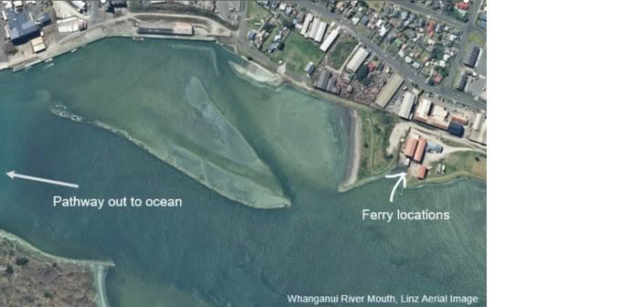
The primary challenge at Whanganui Port is the insufficient water depth, which significantly obstructs commercial occupants such as Q-West Boat Builders, they construct the new electric ferries for the Auckland Harbour crossing. These vessels are significant in size and need to float to the main wharf area for final completion. Unfortunately, the current water levels are too shallow to support this size of boat navigating the port.
Additionally, recreational users struggle to navigate the Harbour due to the highly tide-dependent conditions. This poses a safety risk, especially when weather conditions deteriorate, and can make it even more difficult for boats to return to the boat ramp safely. Currently there is a small window of tide-dependent time in the day when navigation in the area is considered safe for recreational boats.
The shallow depth in the Harbour is the result of extensive build-up of silt and other materials carried down by the Whanganui River over many years. This accumulation has significantly reduced the water depth, affecting both commercial and recreational activities.
The Path to Improved Navigation
A few years ago, a port company acquired an old dredging solution from the South Island in an attempt to address the siltation issue. However, the type of material that had settled at the bottom proved problematic, and the dredging efforts were not as effective as hoped.
In addition to collecting data on the water depth, the hydrographic survey aimed to gather detailed information about the surrounding topographic features. This included mapping a shipwreck at the end of a sandbank, an old wharf, and the sandbank itself. Understanding these features was crucial for comprehensive planning of the dredging project.
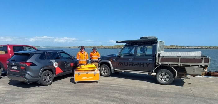
To capture the necessary data, the Surveyors used two main devices: the CHCNAV RS10 handheld laser scanner and the CHCNAV Apache 3 Pro USV. The survey took approx one day on site, with approximately six hours dedicated to using the Apache sonar device and two hours with the RS10 mobile laser scanner.
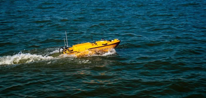
CHCNAV Apache 3 Pro USV
The Apache 3 Pro is a fully integrated unit equipped with a 4G modem, single beam echo sounder, and dual GNSS RTK system. It operates like a GPS rover, connecting to either a UHF base station on site or a SmartFix service. The device provides robust positioning, even under challenging conditions such as navigating under bridges where GPS signals are lost.
The built-in IMU ensures accurate mapping by maintaining a straight line path and correcting for vessel tilt. The system also comes with a 10-inch Android tablet with built-in software for data collection and post-processing.
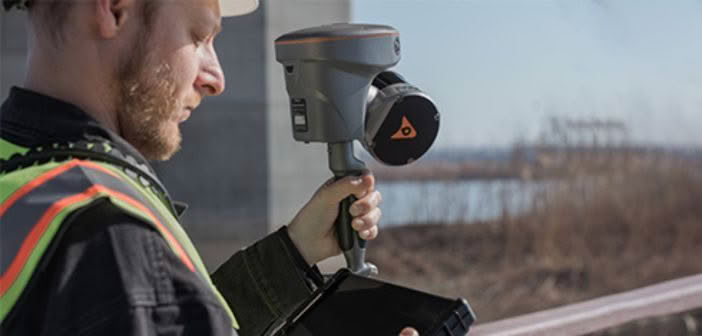
CHCNAV RS10 Scanner
The RS10 mobile laser scanner was used to capture select features around the wharf. This device is portable and user-friendly, making it ideal for detailed topographic surveys. The RS10’s data collection process is intuitive, with real-time camera views and easy-to-use software for post-processing and noise correction.
The Survey Process
On the day of the survey, the team launched the CHCNAV Apache 3 USV using strops to slowly lower the vessel into the water. Alternatively, the vessel can be launched directly off a boat ramp if conditions are right. The Apache 3 Pro is designed to self-right in the water due to its double-layer carbon fiber hull, which provides exceptional impact resistance and buoyancy.
This construction ensures that even if the vessel is dropped from a height of up to 3 meters, it will automatically flip back to its correct orientation, allowing it to remain operational and ready for use.
As the vessel traveled underneath the bridge, the team lost GPS signal. However, the fully integrated IMU worked with the GNSS to provide straight-line mapping. The operator could see the position of the vessel at all times while scanning was in operation, thanks to the GNSS position and the IMU that kept the vessel on a straight line.
 |
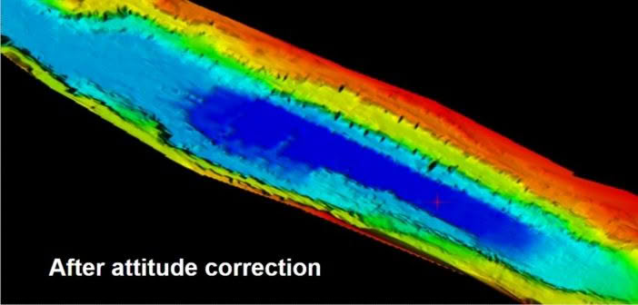 |
The intuitive software was also used to correct the attitude to give a smooth result after capture, ensuring all data was accurate. Obstacle avoidance using radar was a great feature on the day, making capture easier as there were a number of pylons present on the wharf. The vessel could detect these and navigate around them. If more data around the pylons was needed, the vessel could be taken out of automatic mode to record additional information.
The Deliverable
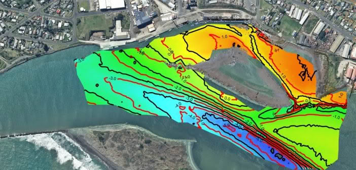
The completed hydrographic data was processed as colour-binned, showing darker colors for shallower water, making it easier to interpret. From this data, it became clear that there was a very clear channel, and around Q-West, there were very shallow waters.
The collected data was processed using Leica Cyclone 3DR software. The final deliverable was a 2D PDF of the waterbed with contour lines at half-meter intervals. The data included a CSV file for the sonar data and a .las file for the RS10 point cloud data. Both datasets were aligned in the local coordinate system, allowing for seamless integration in 3DR.
The processing involved several steps:
- Mesh Creation: Initial mesh creation with an average distance between points set at 7 meters, followed by refinement to fill gaps.
- Hole Detection and Filling: Using external border settings to fill holes while maintaining accurate boundaries.
- Mesh Refinement: Refining the mesh to reduce noise and improve accuracy.
- Contour Line Generation: Creating contour lines at specified intervals for detailed topographic mapping.
- Gridded Inspection and Slope Analysis: Generating additional data views for comprehensive analysis.
The efforts to improve Whanganui Port are crucial for supporting both commercial operations and recreational activities. By addressing the siltation problem with targeted dredging and gathering comprehensive topographic data, the port can continue to serve as a vital maritime hub, promoting safety and efficiency for all who rely on it.
Want to know more about this project?
Watch the full ARCH NZ Webinar presented by Mark Green and Kirsty Mackie here:
SHARE THIS ARTICLE