3D terrain mapping with drones has become common practice over the last decade. Relatively low-cost drones combined with autonomous mission planning apps and user-friendly photogrammetry software (such as ContextCapture and Leica Infinity amongst others) have provided highly efficient workflows for building accurate and complete 3D models of terrain more quickly and safely than traditional ‘boots on the ground’ surveying methods.
While photogrammetry is a powerful solution for many applications, like all technology, it does have some limitations. If your aim is to measure the bare earth surface of a highly vegetated site, then photogrammetry is going to struggle as it can only model what it can see in the imagery. Photogrammetry also struggles on plain, featureless surfaces (as it needs multiple common tie points in overlapping images) and narrow features, such as power lines. Lastly, photogrammetry requires significant machine resources and time to process the 2D drone images into 3D data. For projects that require a quick turnaround on the data, it is significantly quicker to process the raw LiDAR data into a 3D point cloud.
Up until very recently, LiDAR sensors have been too big, heavy and expensive to justify for the 3D mapping of smaller areas but recent advances in the technology have made small, lightweight and highly efficient LiDAR sensors available that can be carried easily by entry level commercial drones such as the DJI Matrice 300 RTK.
| ‘Photogrammetry vs LiDAR’ is a hot topic and there are many myths out there which muddy the waters. In short, there are pros and cons with both and the best choice really comes down to the nature of the site being surveyed and the digital deliverables being requested |  |
The following table, taken from a recent ARCH NZ webinar comparing photogrammetry (using the DJI Mavic 3E & ContextCapture) and LiDAR (using the DJI L1 LiDAR), summaries the advantages of the respective technologies. For a deeper dive, the recording of the webinar is available here.
| Photogrammetry | LiDAR | |
| Capture Speed | ||
| Processing Speed | ||
| Data Management (File Sizes) | ||
| Horizontal Accuracy | ||
| Vertical Accuracy | ||
| Precision (noise level) | ||
| Vegetation Penetration |
The deep dive into the LiDAR data collected for the ARCH NZ webinar revealed some shortcomings using the DJI L1 sensor, particularly with respect to the pass-to-pass matching of overlapping swaths of point cloud data, which were not able to be resolved in DJI’s Terra Pro post-processing software. While the data was still usable for basic terrain modelling, these obvious ‘layers’ in the overlapping point cloud data (up to 0.3m in places) limits its use for applications where a higher order of accuracy and precision is required.
Introducing the CHC AlphaAir 450 LiDAR

The AlphaAir 450 solution is suitable for topographic mapping, power-line inspections, forestry surveys and emergency response. The unit is easy to use and can be rapidly deployed in the field to collect geospatial data.
Advanced Accuracy. By combining industrial-grade GNSS with a high-precision IMU, the AlphaAir 450 can easily achieve an absolute accuracy of 5 cm (vertical) and 10 cm (horizontal) for small survey areas — typically adequate for the most use cases. This higher-grade IMU, limits the pass-to-pass offsets seen on similar systems. To further improve precision and accuracy, users can apply adjustment algorithms in the CHCNAV CoPre software, of which a permanent license is delivered with the sensor with free updates and support for life.
The AlphpaAir 450 also features a built-in, industrial-grade professional 26 MP camera, which provides accurate colourisation of the point cloud and can also be used for dedicated photogrammetry missions.
The proof is in the pudding
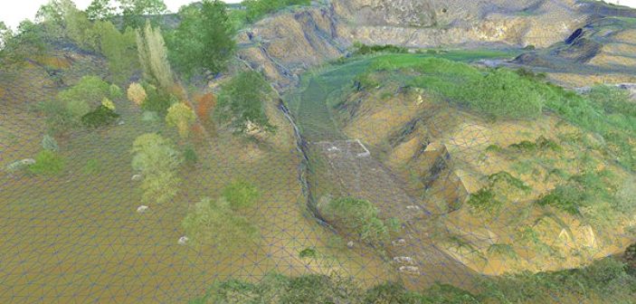
The data collected as part of the ARCH NZ Webinar provided a perfect benchmark against which to assess the quality of the AlphaAir 450 data. This data set included a point cloud from the DJI L1 LiDAR sensor as well as a point cloud from the Leica P40 terrestrial laser scanner. This was controlled and complemented with control points measured with a Leica GS18T GNSS Tilt Rover. The site chosen for the testing, the Halswell Quarry outside of Christchurch, provides around 20ha of varied terrain including grassed areas, hard rock surfaces, roading, buildings and various types of vegetation.
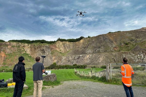
The AlphaAir was attached to a DJI M300 RTK and flown at a speed of 5m/s at a height of 60m above ground level with the overlap of passes set to 50%. The triple echo mode was set to ensure the best possible penetration through vegetation. The mapping mission took around 30 minutes to complete including the pre-flight IMU calibration step. The AlphaAir data was post-processed in the CHC CoPre software using reference station data logged on a SmartFix site 7km away.

Absolute Accuracy
Three 1mx1m black and white targets were laid out and measured with the Leica GS18T to assess the absolute accuracy of the AlphaAir 450 point cloud. The following table shows the absolute accuracy is well within specification (<10 cm Hz, <5 cm V):
| Name | Horizontal Error (M) | Vertical Error (m) |
| 1 | 0.022 | 0.060 |
| 2 | 0.039 | 0.018 |
| 3 | 0.029 | 0.031 |
| RMS | 0.031 | 0.040 |
Relative Accuracy
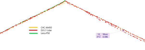
Leica Cyclone 3DR was used to take slices through the data on various surface types in order to assess the relative accuracy (or noise level) of the AlphaAir 450 point cloud.
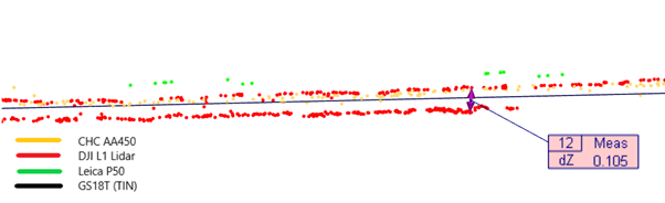
Short Grass
The ‘layering’ of overlapping data commonly seen in the DJI L1 data was not apparent in the AlphaAir450. This is thanks to the combination of a higher quality IMU and better adjustment in the post-processing software.
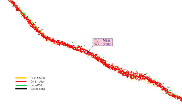
Rock Face
The AlphaAir450 and DJI L1 showed fairly similar noise levels on the hard rock surface of the quarry.
Building Roof
Again, the AlphaAir450 showed no evidence of the ‘layering’ seen in the DJI L1 data.
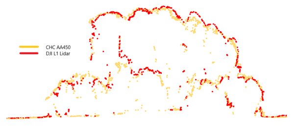
Vegetation (Tree cover)
It is interesting to see that the AlphaAir data shows much more impressive penetration through the vegetation layer to the ground surface than the DJI L1.
Conclusion
For those projects, which lend themselves to LiDAR over photogrammetry, the CHC AlphaAir450 offers an attractive entry point for drone operators looking to extend their offering. It’s very simple to install and operate on the popular DJI Matrice 300/350 and 200/210 drones. The permanent license of the CHC CoPre software, which is delivered with the LiDAR (with free updates for life), allows for the efficient processing of the data through to a 3D point cloud. The software also provides simple but powerful tools to assess the quality of the data and make adjustments if necessary to meet project requirements.
For more information on the full dataset collected or to arrange an on-site demonstration, contact our team on 0800 453 422 or info@globalsurvey.co.nz
The CHC AlphaAir 450 LiDAR is available to hire or buy in New Zealand, with technical support provided by Global Survey’s expert team.
SHARE THIS ARTICLE