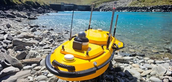
In our latest article, we caught up with the team at Patersons Dunedin office who have been putting the CHCNAV Apache4 hydrographic surveying boat to the test on a long-term coastal monitoring project along the Otago Peninsula.
The Challenges of Monitoring Coastal Change
The project focuses on tracking sand movement along a 1.1 km stretch of coastline where groynes and imported sand have been installed as part of ongoing coastal mitigation. Patersons have developed a proven monitoring methodology over several survey cycles, and their approach combines data collected by photogrammetry at low tide, with an external sounder on a skippered vessel at high tide. GNSS checks consistently confirmed their accuracy within 30–50 mm, with great agreement where data overlaps.
The team were looking for the most efficient way to maintain accuracy whilst also improving safety and reducing costs for their client. Having done their research on the various vessels available in NZ, the Patersons’ Surveyors wanted to test the CHCNAV Apache4 USV.
| “Previously, we needed a capable vessel with a two-person crew, plus the Surveyor — a significant overhead for the client. The Apache4 is fully integrated and purpose-built for marine environments, so we’re not putting people or gear at risk on the water. We can operate closer to the shore, groynes, and other structures, and still collect comprehensive data. On this project, we captured about 25 km of runlines in a single day — the same as our previous method, but with fewer people and less risk.” – Jason Eichstaedt – Dunedin Survey Principal, Patersons |  |
Getting Hands-On with the Apache4 Hydrographic Survey Boat
Before the testing started, the Patersons team turned to Richard Harrison from Global Survey to answer their technical questions and provide comprehensive hands-on training in both the autonomous and manual modes of operation.
Environmental factors such as temperature and salinity can affect sound velocity in water and influence depth readings. The Apache4 compensates for this automatically, with built-in sensors and configurable settings that can be tailored to local conditions like those found in Otago Harbour.
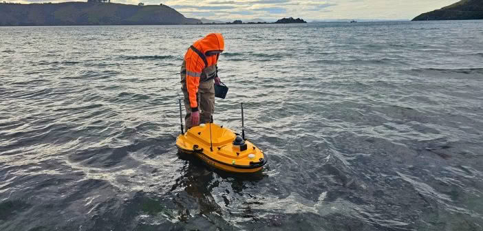
“Operating the Apache4 feels a lot like flying a drone. You define your mission, set runlines and sounding parameters, and let the vessel get to work. We ran surveys in choppy water, close to rocky structures, and in depths ranging from 0.4 to 7 metres. The boat handled both wind and waves really well — its low profile keeps it stable. Using Easysail software, we were able to post-process the data to remove pitch, roll, yaw, and heave effects. The final results showed excellent agreement with our Photogrammetry and GNSS measurements.” Murray Pitts – Dunedin Senior Survey Technician, Patersons

Proven Performance in Tough Conditions
Areas of “white water,” such as where the vessel moves through waves or turbid areas, can be easily identified and cleaned in post-processing. Automatic depth-based power output and gain control optimise the quality of soundings while responsive, protected motors make it easy to operate in tight or weedy areas.
The Apache4 includes advanced safety features such as “Return to Home” on low battery, lost signal and collision-avoidance sensors for navigating around piles, buoys and other obstacles. These safeguards also help satisfy harbourmasters and other responsible parties of the vessel’s suitability for professional use.
The vessel also supports multi-beam sensors for high resolution hydrographic surveys and ADCP sensors for river flow modelling. Processing revealed excellent agreement between the photogrammetry, GNSS and sounding data, providing clear comparisons between monitoring epochs.
Patersons’ Wānaka team were also keen to put the Apache4 through its paces in a challenging survey at the Lake Hāwea tailrace. Fast-flowing, turbulent water made it a true test of the vessel’s capabilities — and the results spoke for themselves as everyone was impressed!
“Deployment was simple and we captured the data we needed in about 15 minutes. That kind of speed means we can easily complete multiple sites in a day. Other vessels have struggled in these conditions, but the Apache4 handled it without issue and delivered a detailed, accurate riverbed model for our engineering design work.” Alex Cranswick – Wānaka Senior Survey Technician, Patersons

Improving Safety in Hazardous Environments
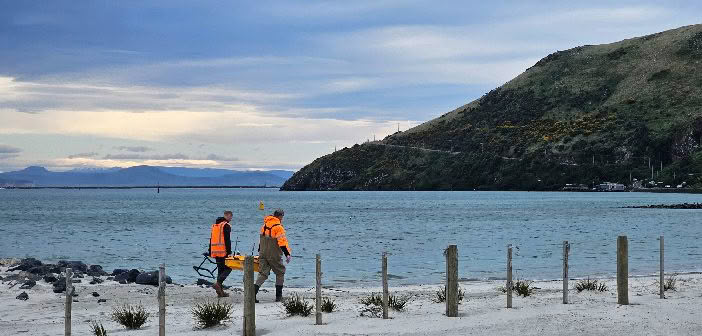
Innovative technology that is smart and purpose-built for Surveyors has the ability to transform the data collection and processing on hydrographic surveys and coastal monitoring projects. A key consideration when choosing technology is not just efficiency, but also how it can be used as an engineering control to reduce the risk of hazards. Surveyors can operate the Apache4 from the shoreline with improved safety and eliminate many of the associated risks they would face onboard manned boats.
 |
“Seeing these projects reinforces what we already know —The Apache4 gives professionals like Patersons the ability to collect accurate, high-quality hydrographic data safely and efficiently, even in complex or hazardous environments. At Global Survey, we’re proud to support survey teams across New Zealand with the tools, training and expertise to push the boundaries of what’s possible.” Richard Harrison – Geomatics Specialist, Global Survey |
Reach out to our Survey team to find out more about the CHCNAV Apache4 hydrographic surveying boat.
SHARE THIS ARTICLE