Project Overview
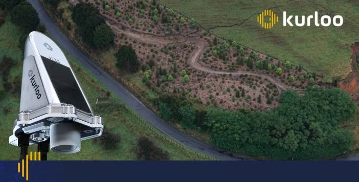
Following prolonged, intense rainfall in April–May 2025, Christchurch City and Banks Peninsula experienced flooding and multiple landslides, resulting in a state of emergency. Significant cracking was found along a section of Lighthouse Road and surrounding land. The road was closed, and affected residents were evacuated as a precaution.
The slip posed immediate risks of collapse, debris flow and further instability, threatening safety, access, local businesses, daily commutes and resident access to homes. Traditional manual surveys were insufficient for the dynamic post-rainfall environment, where seismic or further rainfall events could exacerbate the slip.
Key Considerations:
- Safety Risks: Potential for sudden failure endangering motorists, residents, and properties downslope.
- Community and Economic Disruption: Road closure led to detours, impacting local businesses, daily commutes, and resident access to homes.
- Planning Pressures: Council needed rapid, reliable data to comply with emergency protocols and plan capital works.

“Christchurch City Council had the ability to carry out manual monitoring at the site, but also wanted the option of automated monitoring. Our in-house survey team had heard about Kurloo equipment and recommended we investigate whether it would meet our needs.” — Brent Smith, Christchurch City Council
The Kurloo Solution:
Automated, Precise Monitoring Kurloo’s GNSS/IoT technology was deployed to monitor ground movements on Lighthouse Road, providing millimetre-accurate, continuous data tailored to the site’s rainfall- and seismic-induced risks, both vertical settlement and lateral displacement.
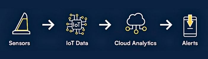
- Rapid Deployment: Solar-powered GNSS sensors installed across key zones (e.g., slip crest and abutments) in three days, with no disruption to emergency response efforts or ongoing borehole drilling.
- Precision Data: Cloud-based platform tracks movements at millimetre resolution, delivering automated alerts (via SMS/dashboard) for deviations >2mm, integrated with CCC’s geotechnical tools.
- Resilient Operation: Low-maintenance units withstand harsh New Zealand weather, enabling remote oversight and reducing on-site visits significantly.
This scalable system supported CCC’s geotech and surveying teams to transition from crisis response to long-term resilience.

The Results: Safety, Efficiency and Cost Savings
| Metric | Before Kurloo | After Kurloo | Impact |
| Monitoring Frequency | Ad-hoc manual surveys post-emergency | Continuous, every 3 hours | Significantly more data for real-time decisions |
| Detection Time | 24+ hours via periodic checks | <3 hours | Enabled proactive interventions, preventing collapse risks |
| Road Uptime | Road closed, affected residents evacuated | Re-opened with restricted access | Minimised disruptions and allowed resident returns |
| Cost Savings | High emergency response/labour costs | Reduced on-site visits | ROI through informed, targeted capital works |
| Risk Events | 1 major slip in May | Zero additional movements detected | Enhanced community safety and compliance |
Wider Impact
Kurloo helped provide the confidence needed for residents to return home and for the road to reopen with restricted access, thanks to continuous, real-time monitoring data. The system also reduced the need for frequent site visits, helping lower emergency response demands and associated labour costs.
Beyond the immediate response, the monitoring data supported more informed decision-making around future capital works, helping ensure investment was targeted where it would deliver the greatest value.
The success of the project also attracted interest from another South Island council that was dealing with its own state of emergency following severe rainfall. By sharing data and insights from the site, CCC was able to demonstrate the benefits of continuous monitoring and how it can support safer, more confident decision-making during and after emergency events.
Outcome
Over an extended monitoring period, including another significant wet weather event, the data showed no further movement at the site. This confirmed that the risk of a debris flow was low, largely due to the site’s high clay content, even under future heavy rainfall conditions.
With reliable monitoring data in place, Kurloo enabled CCC’s geotechnical and surveying teams to move from a reactive emergency response approach to a more proactive, long-term resilience strategy, providing confidence in both the site’s stability and future management decisions.
For more information, contact our monitoring specialists on 0800 453 422 or info@globalsurvey.co.nz

