
The recent industry survey by Deloitte for Autodesk “The state of digital adoption in construction report 2023” showed that businesses using digital technologies are more likely to be successful across a number of measures including revenue growth and optimism about the future.
The adoption of digital technologies under an organisation-wide strategy that includes training and adequate investment is crucially important to success, particularly as 40% of the construction industry businesses measured in the report (including Australian businesses) are now using Building Information Modelling (BIM) technology.
Augmented reality in construction – an accessible emerging technology
One of the most exciting and relevant new digital technologies is Augmented Reality (AR). AR offers gains across the construction industry with benefits for site safety, utilities design, visualisation and asset management across the civil and commercial sectors. New Zealand transport planning and engineering specialists Abley recently collaborated with Global Survey on a paper focused on the requirements for successful implementation of AR in construction using vGIS Augmented Reality
AR in this context is the overlay of digital data onto your real world view via smart devices such as smartphones, tablets or headsets such as hololens. This data can be 3D or 2D and may also be extended with the ability to view and interrogate digital twin attributes (such as materials, pipe sizes). The best AR tools also allow for the capture of new data through the same AR interface. This may be acquiring or maintaining spatial data, completing or logging field reports and capturing additional attribute information.
Suitable devices can be Android or iOS, consumer or professional but there is significant onboard processing overhead so invest in a higher end device that meets the recommended specs on the vGIS portal. Integrated LIDAR sensors help significantly with stabilisation of the AR view and with spatial data capture.
The power of visualisation
Reliable and repeatable visualisation is very important in most applications, for which high accuracy GNSS receivers such as the Leica FLX100 PLUS RTK GNSS receiver is ideally suited. The FLX100 is flexible enough to be handheld or pole mounted and delivers a 2cm RTK solution when paired with Global Survey’s SmartFix RTK network.
SmartFix covers most of the areas you want to work with stable NZGD2000 reference station coordinates so you are placed reliably in terms of the survey grid system. vGIS extends traditional AR capability through working inside buildings using Leica total station technology for reliable 3D positioning.
To address some in the concerns identified by the Deloitte/Autodesk report, AR tools need to be intuitive for the widest pool of field users and require minimal training. But they work best when the underlying data is well prepared and presented, which Abley’s Gavin Jeter discussed at the Rotorua conference. While data preparation is within the capabilities of many survey and geospatial practitioners, there are some measures that improve the overall user experience.
Federation of native source data from industry standard files
vGIS is an AR solution that allows for the federation of your native source data from many different GIS, BIM and CAD formats. The data may be 2D or 3D, with each having its own benefits but the key is to prepare the underlying schema once, then as the design changes, the changes move out to the AR tools with no or minimal interaction. Multiple data types are supported by vGIS including Autodesk, Bentley and ESRI formats, plus streaming WFS data. The full list of supported datatypes is available here. Gavin recommends gaining efficiencies in visualising larger datasets by generalising your 3D data and reducing textures as much as possible prior to loading the design data.
Each design feature should be delivered on its own layer, enabling the field team to turn layers on and off as they need them. vGIS allows allocating different datasets to different field teams, following the principle of preparing the data schema once, then tuning the delivery to just what each field team needs.
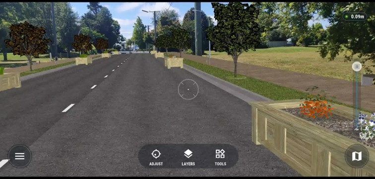
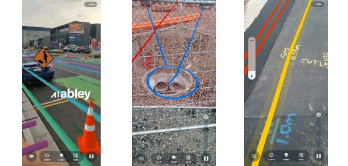
Abley have produced highly effective AR visualisations for civil construction including traffic management schemes that can be used to view the scheme in the real world prior to laying it out, or to verify that what has been laid out matches what was intended.
Projects also include the AR display of underground services and utilities, overlaying 3d survey asbuilt data to identify the location of underground services without need for potholing. Abley have also developed asset data capture tools to a well-defined schema which controls the way the spatial data is captured through the AR interface, as well as the attribution that goes along with it.
For more information on optimising the preparation of your spatial and attribute data, contact the Abley team.
Talk to Richard Harrison at Global Survey about Augmented Reality in Construction, vGIS and GNSS solutions.
SHARE THIS ARTICLE