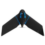


DJI has rethought its drone technology from the ground-up, revolutionising its systems to achieve a new standard for drone accuracy – resulting in the creation of the Phantom 4 RTK.
The system was designed by looking at the requirements from the drone mapping and surveying market and building what they wished for – a small drone solution with a high-resolution camera and the ability to capture centimeter-accurate RTK data.
With a new RTK system, redesigned internals resulting in TimeSync and a turnkey flight application, the Phantom 4 RTK enables the surveying community to conduct the workflow operation efficiently.
DJI Phantom 4 RTK features:
- 30 min Flight Time
- 7km Control Range
- Horizontal RTK Accuracy of 1cm + 1ppm
- Vertical RTK Accuracy of 1.5cm + 1ppm
- Ocusync Video Transmission
- 5 Direction Obstacle Sensing
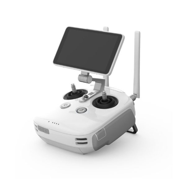
RELIABLE TRANSMISSION
Equipped with OcuSync 2.0, the drones now support automatic dual frequency band switching between 2.4GHz and 5.8GHz for up to 8 km maximum transmission range, delivering reliable, high-resolution, low-latency digital video transmission back to the pilot.
DATA SECURITY
All data transmitted through OcuSync 2.0 is encrypted using the leading AES-256 standard, ensuring critical mission information is protected and can only be accessed by authorized parties.
FLIGHT SAFETY
Designed with U.S. Federal Aviation Administration Night Waiver standards in mind, anti-collision beacons have been added on the top and bottom of the drone to improve flight safety during low-light conditions and at night. The drone is also equipped with DJI’s AirSense system using an ADS-B receiver to provide drone pilots with awareness of approaching air traffic that may pose a collision risk.
FLIGHT PERFORMANCE
A new TimeSync system continuously aligns the flight controller, cameras, GPS module and RTK module, as well as any third-party payloads or onboard accessories, fixing the position data to the centre of the image frame to achieve improved data accuracy.
ANTI-COLLISION BEACON
Equipped with new top and bottom anti-collision beacons, the V2 drones are visible at night or in lowlight conditions, making operation in less than ideal conditions safer.
DATA ACCURACY
Equipped with OcuSync 2.0, the drones now support automatic dual frequency band switching between 2.4GHz and 5.8GHz for up to 8 km maximum transmission range, delivering reliable, high-resolution, low-latency digital video transmission back to the pilot.
OBSTACLE AVOIDANCE
A robust FlightAutonomy system with front, bottom and upper sensors detect and avoids obstacles while enabling precision hovering so that you can fly with confidence.
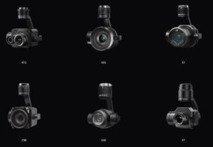
COMPATIBLE PAYLOADS
The V2 series is still capable of using third-party payloads
- ZENMUSE XT2
- ZENMUSE X5S
- ZENMUSE X7
- ZENMUSE Z30
- ZENMUSE X4S
- ZENMUSE XT
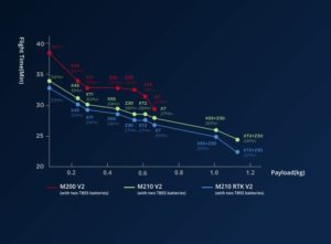
FLIGHT TIME BASED ON PAYLOAD CONFIGURATION
INTELLIGENT FLIGHT MODES
ActiveTrack: Keep moving subjects in a frame while you fly with ease to capture detailed data. Perfect for keeping track of missing persons while you relay their position to a rescue team.
Point of Interest: Easily circle your object of interest to focus on capturing the data needed for a detailed inspection.
Obstacle Avoidance: A robust FlightAutonomy system with front, bottom and upper sensors detect and avoid obstacles while enabling precision hovering so that you can fly with confidence.
RELIABILITY
Powered by TB55 batteries to properly support a dual gimbal configuration and increase flight times.
Dual batteries for improved reliability
Self-heating encasing for flight in sub-zero temperatures
APPLICATIONS
Power Line Inspection: Easily visualize extensive power line networks in remote areas.
Search and Rescue: Act quickly to locate missing people and better plan rescue missions.
Wind Turbine Inspection: Conduct safe and rapid wind turbine inspections with more ease than ever before.
Bridge Inspection: Perform inspections of bridges and complicated structures with a top-mounted camera.