Designed to facilitate the shift from traditional measurement methods using tapes and strings, to modern digital methods, the Leica iCON GPS 30 offers an easy-to-use and economic solution for construction measurement tasks.
Equipped with Leica iCON field software, the Leica iCON GPS 30 can be used to:
- Increase productivity of any construction project by adapting digital measurement methods
- Define and document the position of water and sewer lines, oil and gas pipes or power and communication lines as part of the utility construction process
- Stakeout outlines for subsequent building construction tasks or subdividing real property
- Transfer outlines from design to field in landscaping projects or road construction
- Simple survey of ground control points for UAV workflows
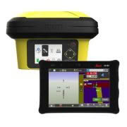
Designed with the operator in mind, the iCON GPS 30 is an exceptionally lightweight and compact GNSS RTK rover, providing consistently accurate positions through advanced RTK technologies.
Integrated with the well-established Leica iCON field software, tailored to typical construction workflows, the iCON GPS 30 speaks the language of construction site professionals.
Leica iCON GPS 30 is compatible with:
- Leica iCON CC70 and Leica iCON CC180 field controller
- Leica iCON field software: Either Leica iCON Site for civil construction or Leica iCON Build for vertical construction.