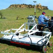
Stream EM is a multi-channel ground penetrating radar solution dedicated to utility locating and mapping.
The solution has been developed to cover tens of hectares/day, obtaining the best utilities detection quality thanks to 40 separate channels. Stream EM includes double polarized (VV and HH) antennas to cover wide road surfaces. The system maintains the same maximum data collection speed, 15 Km/h, with only longitudinal scans for both longitudinal and transversal pipes detection.
Stream EM enables the user to map all underground utilities in large areas, delivering clear and accurate results across hundreds of Km2. The high number of antennas increases the quality of the data achievable.
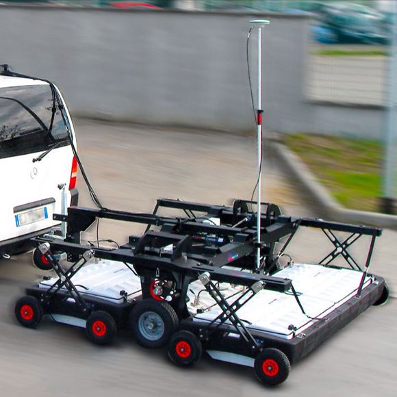
The system can be easily disassembled for transport in a van size vehicle. It can also be reconfigured for mapping sidewalks and difficult areas / other applications such as archaeology, environmental, road/runway.
Stream EM Key Features:
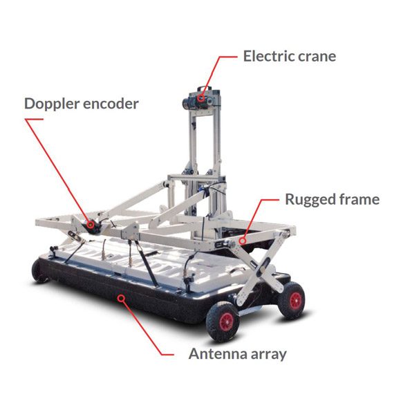
- Massive array of 40 antennas in two polarisations: A massive array of 40 antennas ensures a high sampling density. This results in accurate 3D modeling of the subsurface and ease of detecting buried targets and anomalies. The use of both polarisations provides optimal detection of main and junction pipes at the same time.
- Speed: Stream EM can be towed by a car up to 15 km/h:
- Survey many miles per day
- Be operated by only two people
- Run continuously without interrupting traffic
- Keeps the crew safe inside the vehicle.
- Accurate to less than 5cm: Stream EM can be interfaced with GPS or a total station to accurately geo-locate the surveyed area. All the pipes, cables and anomalies are detected with high accuracy and are individually distinguishable.
- Professional Subsurface Utility Engineering (SUE) survey: Pipes, cables and buried object can be automatically transferred to CAD and GIS format with a proprietary software tool.
Benefits of Stream EM:
- Improved management of underground utility design, relocation and coordination
- Cost and time reductions: No need to block traffic or perform surveys at night
- Increase in accuracy with a detection accuracy of as little as 5 cm
- Increase productivity and have the ability to detect every buried target
- Highly modular structure allows it to be reconfigured to map sidewalks and difficult to access areas
Real time software for advanced viewing
Stream C is supplied with the OneVision and GRED HD 3D CAD software suites.
OneVision
OneVision – Acquisition software for use in the field. Providing real-time target viewing, onsite object mapping and GPS navigation, OneVision is a software application for advanced GPR data collection This powerful tool can be used with an array of antennas when performing utility mapping, archeological and environmental surveys, and extensive mapping of medium to large size projects.OneVision is available for:
- Stream EM
- Stream X
- RIS MF Hi-Mod
OneVision is a powerful application for advanced surveys with integrated navigation, featuring:
- Real-time tomography on a cartographic background (e.g. Google Maps, GeoTIFF and KML)
- Multi-view screen with GPR radar maps (B-scan and T-scan), radar tomography (C scan) and cartography
- Survey planning tools
- Special function allowing tomographic merging of transversal and longitudinal swathes
- Continuous monitoring of GPR and GPS statuses
- Survey management with interactive and on-site target mapping as well as review and editing
- Automatic Pipe Detection (optional)
OneVision provides increased productivity and reduced costs. Other benefits include:
- Immediate decision-making with real-time on-site detection
- Target recognition removing the need for specialist skills
- Immediate understanding of complex environments (e.g., urban areas) with the tomographic map in real time
- Complete coverage is always provided in a single visit with integrated acquisition and navigation functions
GRED HD 3D CAD – specialised integration software
Specifically designed to offer an integrated framework for CAD and GIS, GRED HD 3D CAD combines the characteristics of industrial productivity with high levels of reliability.
The software offers the fast creation and display of 2D and 3D tomograms in just a few minutes after basic filtering. Raw data, structures and objects of any generic shape are able to be directly exported to CAD or GIS maps.The software is fully compatible with any GPS or positioning data in order to obtain automatically geo-referenced data plots.
Key features include:
- Real-time display of trajectories using GPS or Total Station.
- 2D and 3D tomography for an immediate visualisation and detection of anomalies.
- Automated transfer to CAD/GIS: the identified target can be automatically transferred to CAD or GIS maps for professional SUE / utility mapping.
- Geolocated data information and visualisation