All in One Solution – Leica MC1
Leica Geosystems intelligent and intuitive hardware and software combination combines the MCP80 Panel and MC1 Software into one common platform which can be used across all machines
Leica iCON MC1 3D Dozer Solution is the perfect tool for increasing the productivity and precision of your dozer. Leica offer the full range of solutions for fixed bull blades and 6-way blades delivering outstanding precision and productivity.
Configure your machine with the most complete range of dozer solutions on the market:
- Single Mast GNSS for fixed bull blades
- Single Mast Total Station Control for high accuracy work with box blades
- Dual Mast GNSS with SP inertial technology for high speed grading for bull blades or 6-way
- On Cab Dual GNSS
Leica iCON MC1 3D Dozer Solution “plug and play” seamlessly into all the major machine brands reducing cost and the need to install hydraulic valves. Regardless of the make and model of your dozers, graders and excavators, Leica provide you with one seamless solution across your fleet.
The SP sensor includes the latest inertial sensor technology which increases grading speed by a factor of 2 to 3 over conventional systems. Run your dozer to the extent of its capabilities while constantly maintaining grade. The highest precision at the fastest speed ensures faster results without losing accuracy.
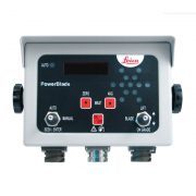
The next generation of machine control hardware from Leica Geosystems combines advanced technology with simplicity. Designed to be fully interchangeable and future-proofed across all machine types, the new MCP80 intelligent machine control panel keeps you powered on, whatever your project demands
The Leica range of automated dozer solutions allow you to use your dozer for fine grading applications and final trim, similar to how you would use a grader. Deliver faster results and increased productivity with the iGD4SP solution, now you can operate dozers at full speed with maximum accuracy.
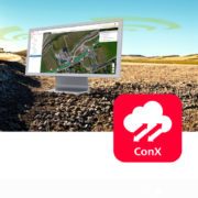
As the project needs change, you need to respond quickly. Take full-control of your site from any desktop or tablet via Leica ConX, a cloud based collaboration tool designed to efficiently manage all your connected construction projects. Access the online dashboard and view equipment on all your job sites in real time, see progress updates, run reports and update design files remotely.
Designed to be fully interchangeable across your entire fleet, the new MCP80 intelligent machine control panel keeps you powered on, whatever your project demands.
Grading
Grading uneven surfaces can be done with speed and ease. Leica dozer solutions make grading complex jobs simple. Maximise your productivity by automating your dozer with our ability to “plug and play” into all modern machines or use a hydraulic valve if your machines a little older.
Bulk Earthworks and Civil Construction
Load any 3D design file into the system and get real time cut and fill values displayed on the screen allowing the operator to cut to grade with each pass. Add the option of automatic control for final finishing.
Formation Layering
When filling material in formations, simplify the process by entering the desired material depth and slope required. Gain consistent compaction by building your project in layers.
The Leica MCP80 control panel is one intelligent machine control system across your fleet, one common interface and seamless cable-free transfer between machines, regardless of type, make or model.
- Built with tough environmental specifications, the Leica Geosystems docking station and MCP80 panel are designed to operate in extreme temperatures (-40 °C to +65 °C) and are IP66 water, vibration and shock proof.
- Fully supports iCON ConX for cloud connectivity, data exchange and dashboard style performance reporting.
- Run machines in automatic mode and keep precision without needing to rework areas.
- Supports industry standard AutoCAD DXF/DWG and Land XML files directly on the machine.
- The most advanced 3D graphics in the industry allowing the operator to visualise the project at any time.
- Operator-friendly, easy-to-understand user interface reduces training time / costs and enables the creation of simple terrain models directly on the screen.
“Using a single supplier, Global Survey, and single brand, Leica, for all our positioning, measurement and machine control technology means everything on site integrates seamlessly, and as a result return on investment has been very rapid. Global Survey’s after sales support has been amazing and definitely a reason for us continuing to work with them.”
Conal Dempsey, Managing Director
Dempsey Wood Civil Ltd