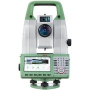


An update to the world’s first self-learning MultiStation that automatically adjusts to any environment, regardless of the challenges.
To meet the demands of our ever-changing and increasingly-quicker world, Leica Geosystems developed the world’s first MultiStation, combining all available measurement technologies in one superior instrument. As a 1” second instrument, the Leica Nova MS60 ensures accuracy for any project.
Scanning and in-field result delivery with the Leica Nova MS60 has been made simpler through the instant creation of point clouds, images and/or 3D models, and comparisons in one view. Visualisations are clearer and easier to see on the 5” screen. The unique capabilities of the Leica Nova MultiStation truly deliver the new experience in measuring technology.
The NEW Leica Nova MS60 MultiStation Delivers:
Increased Scanning Speed
The biggest improvement of the new model Leica Nova MS60 is the increase in scanning speed to 30,000 points per second.
AutoHeight: Revolutionising Instrument Height Measurement
The Leica Nova MS60 offers the AutoHeight feature as standard. AutoHeight enables the instrument to automatically measure, read and set its instrument height. Prevent time consuming manual effort and eliminate critical errors during the instrument setup when this revolutionary feature uses a laser from the instrument to measure to the ground and automatically passes the measurement to the software.
Engaging Software
The Leica Nova MS60 MultiStation comes with the revolutionary Leica Captivate software, turning complex data into the most realistic and workable 3D models. With easy-to-use apps and familiar touch technology, all forms of measured and design data can be viewed in all dimensions. Leica Captivate spans industries and applications with little more than a simple swipe, regardless of whether you work with GNSS, total stations or both.
Leica Captivate Inspect Surface App
Leica Captivate Inspect Surface app enables users to perform point cloud analysis, such as flatness visualisation and asbuilt checks in the field. For example; you can now measure the asbuilt road surface and compare it the original road design. In the field you can see all the out of tolerance areas, and create a comprehensive report of the surface whilst onsite.
Infinitely Bridging the Field to the Office
While Leica Captivate captures and models data in the field, Leica Infinity processes the information back in the office. A smooth data transfer ensures the project stays on track. Leica Captivate and Leica Infinity work in conjunction to join previous survey data and edit projects faster and more efficiently.
Customisable packages
A portfolio of intuitive software for any application gives you the freedom to choose how you want to work. Leica Cyclone, Leica GeoMos, Leica Infinity, various Hexagon software packages and selected partner third-party software can be integrated into your workflow to create the customised solution for your specific need. Whatever you choose, you’ll enjoy an immersive experience that goes well beyond the data.
Protect Your Total Station with Leica LOC8
Leica LOC8 is a positioning, tracking and locking solution for Leica total stations, which enables users to remotely track and lock instruments on demand.
With this feature users can remotely lock and unlock their total stations, receive notifications of the total station’s whereabouts, and set up geo-fencing to ensure that instruments are not removed from specified areas. These features help to minimize the risk of theft and the costs involved with replacing expensive equipment.
Leica LOC8 can be installed at the time of purchase or it can be retrofitted by a Leica accredited Technician at one of our Service Centres.