All In One Solution – Leica iCON MC1
Leica Geosystems intelligent and intuitive hardware and software combination combines the MCP80 Panel and MC1 Software into one common platform which can be used across all machines
Leica iCON MC1 3D Excavator Solution guides the operator using reference models and GNSS in 3D. Design are displayed in 3D and real time cut/fill indications are displayed your MCP80 Control panel. This allows you to rapidly excavate to your design increasing efficiency for operators.
Reach new levels of productivity by using Leica Copilot to easily integrate your tilt rotator into your Leica iCON MC1 3D Excavator Solution.
Improved Data handling
Leica iCON MC1 simplifies design data handling and is open to all standard design data types, enabling a flexible dataflow to support common workflows on a job site. All machinery on the construction site, as well as Leica iCON site field solution, are now running on the same design data structure, meaning that no data conversion is required. Furthermore, a seamless data transfer between machines, field units within the job site and office are guaranteed.
Reduce costs, increase productivity
Consistency in software design throughout all heavy machine control applications reduces our customers’ training efforts and optimises their learning curve. The same software platform can be used with different sensor configurations, which improves scalability and training. Furthermore, installers benefit from simplified installation and service processes.
Simplified work progress
An intuitive graphical interface with customer-centred design supports our customers in getting their job done faster and more precisely. The software interface is uncluttered and with familiar symbols to help the operator focus on the important steps. An intelligent licensing system facilitates the add-on of another machine solution, giving users full flexibility in their machine control solutions.
As your project’s needs change, you need to respond quickly. Take full-control of your site from any desktop or tablet via Leica ConX, a cloud based collaboration tool designed to efficiently manage all your connected construction projects. Access the online dashboard and view equipment on all your job sites in real time, see progress updates, run reports and update design files remotely.
Automating the excavator
The new semi-automatic functionality for excavator offers partly or fully automation of the boom, bucket, tilt bucket or tiltrotator. Use the semi-automatic excavator functionality to perform complex excavation tasks such as slope creation and trenching faster and more accurately. Other automating features such as iXE CoPilot help the operator to work with less fatigue and higher working comfort with resulting less over digging and reduced operational costs.
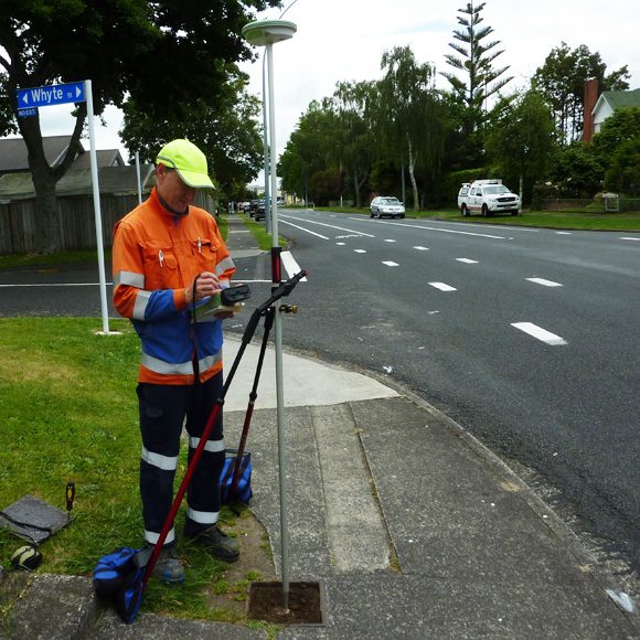
High accuracy machine control for compact excavators
Add machine control to mini excavators with swing boom, and benefit from all the advantages of machine control such as higher accuracy, digital workflows and as-built documentation. Compact excavators with swing boom are designed for trenching and excavating in areas where larger equipment can’t operate. The machine’s swing boom moves independently, so you can dig alongside obstacles with better visibility. Leica Geosystems offers a flexible solution with swing boom sensor or manual calculation of the position of the swing boom.
Leica iCON MC1 integration with safety solutions
Leica iCON MC1 3D Avoidance Zone Solution An integration of Leica iCON MC1 machine control and the Xwatch safety system to deliver a complete 3D avoidance system that greatly improve safety onsite. Set up 3D avoidance zones to protect assets either alongside, above or below the construction site whilst work is underway.
Leica iCON PA80 Integrates the personal alert PA10 system with iCON MC1 machine control. The machine operator receives visual and audible warnings directly in the cab. Pedestrians with a PA10 tag can trigger a panic alert that will notify the machine operators or vehicle drivers with PA10 or PA80, within 50m range.
Bulk Earthworks and Civil Construction
Load any 3D design file into the Leica iCON MC1 system and get real time cut and fill values displayed on the screen of your excavator allowing the operator to cut precisely.
Trenching
Use the Leica iCON MC1 system to provide depth guidance for any trenching application. Work directly from the original 3D terrain models, or 3D line work to cut your trench to grade first time. All this without the need for grade checkers to enter the trench.
Submerged Cuts
Use the Leica iCON MC1 system to excavate underwater – designed specifically for dredging, clearing and operating in water. The Leica iCON MC1 system colour maps as you excavate so you can track where has been excavated and what work still needs to be done.
Formation Layering
When filling material in pipe trenches or formations, simplify the process by entering the desired material depth and slope required. The system stores multiple depths and slopes for several layers.
Height Alarm
Safety First – When digging in surroundings where there are objects above the excavator that are potentially dangerous (e.g. power cables), a Height Alarm can be set which warns the operator of boom, stick, and bucket heights in relation to the hazard.
- The Leica MCP80 control panel allows for one intelligent system across your fleet, one common interface and seamless cable-free transfer between machines, regardless of type, make or model.
- Built with tough environmental specifications, the Leica Geosystems docking station and MCP80 panel are designed to operate in extreme temperatures (-40 °C to +65 °C) and are water, vibration and shock proof.
Fully supports iCON ConX. - Supports industry standard AutoCAD DXF/DWG and Land XML files directly on the machine.
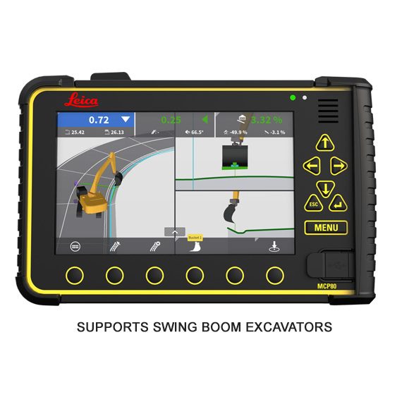
- 3D Graphics – The most advanced 3D graphics in the industry and the only solution with 3D graphical views.
- Compatible with all makes and models of excavators on the market – even dual boom excavators.
- Precise sculpting of edges, slopes and contours with tilt rotator attachments.
- USB data transfer enables transfer of files ON and OFF the system.
- Operator-friendly, easy-to-understand user interface reduces training time / costs and enables the creation of simple terrain models directly on the screen.
- Switch between 2D and 3D view with the touch of a button.